|
search place name
|
||
Melîyech (Tétouan, Morocco)Melîyech is a town in the Tétouan region of Morocco. An overview map of the region around Melîyech is displayed below.
regional and 3d topo map of Melîyech, Morocco ::

Melîyech airports ::
The nearest airport is TNG - Tanger Ibn Batouta, located 31.0 km west of Melîyech.
Other airports nearby include TTU - Tetouan Saniat Rmel (36.7 km south east), GIB - Gibraltar (41.9 km north east), XRY - Jerez (109.2 km north), AGP - Malaga (136.0 km north east), Nearby towns ::
Meliyech (1.1km south) //
Hammidane (1.3km south east) //
El Harroujine (1.8km south) //
Zhara (2.1km east) //
Fardioua (2.2km west) //
Lechba (3.8km south east) //
Farsiouâ (3.5km south east) //
Ksar es Sghir (3.7km north east) //
Dchar Foual (5.1km south) //
Aguenouane (5.5km south west) //
Mrarech (5.3km west) //
El Hammoumi (6.4km south west) //
Aïn er Rmel (6.9km south) //
Aïn el Hamra (7.4km south) //
Bou Abbad (6.9km south east) //
Khandak Zrarah (7.0km west) //
El Mansoura (7.1km east) //
Ghzeilech (9.0km south) //
Agaouz (7.5km north east) //
Aïn Saïd (10.2km south west) //
El Hamma (10.9km south east) //
[all distances 'as the bird flies' and approximate] 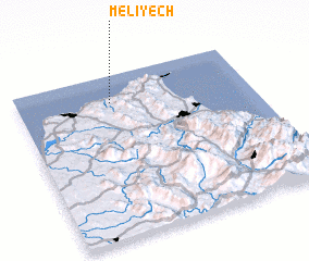 Places with similar names to Melîyech, Morocco ::
Disclaimer :: Information on this page comes without warranty of any kind |
||
|
Where is Melîyech? Elevation and coordinates ::
Latitude (lat): 35°50'0"N Longitude (lon): 5°36'0"W
Elevation (approx.): -32768m (map arrows pan, magnifying glasses zoom) |
||
|
Visiting Melîyech? Hotel/Accommodation ::
Book a hotel in Melîyech Travel Guide ::
Buy a travel guide for Morocco rental cars ::
car rental offers GPS waypoint ::
download a GPX waypoint (PoI) of Melîyech for your GPS receiver
|
||