|
search place name
|
||
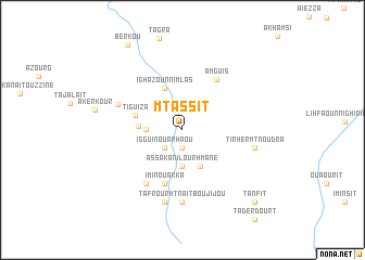
Mtassit (Ouarzazate, Morocco)Mtassit is a town in the Ouarzazate region of Morocco. An overview map of the region around Mtassit is displayed below.
regional and 3d topo map of Mtassit, Morocco ::
Mtassit airports ::
The nearest airport is OZZ - Ouarzazate, located 98.3 km west of Mtassit.
Other airports nearby include ERH - Er-rachidia Moulay Ali Cherif (175.9 km north east), Nearby towns ::
Maouas (1.9km south) //
Iggui nʼOu Arhaou (2.4km south west) //
Assaka nʼIlourhmane (3.7km south) //
Hamdour (3.7km south) //
Amguene nʼSfia (3.2km west) //
Tamarendout Tamajialt (4.0km south east) //
Bou Tigguit nʼOualrkit (3.9km west) //
Ighazoun nʼImlas (4.6km north) //
Tiguiza (4.5km west) //
Imi nʼOu Akka (5.8km south) //
Amguis (6.0km north east) //
Zguigui (6.4km south west) //
Berkik (6.3km north west) //
Tafrourht nʼAït Bou Jijou (7.4km south) //
Tassaount nʼOusdidene (6.6km east) //
Tirhermt nʼOudra (6.6km east) //
Tadaout nʼAït Ben Ichchou (7.6km south) //
Berkou (10.0km north west) //
Tanfit (9.8km south east) //
[all distances 'as the bird flies' and approximate]  Places with similar names to Mtassit, Morocco ::
Disclaimer :: Information on this page comes without warranty of any kind |
||
|
Where is Mtassit? Elevation and coordinates ::
Latitude (lat): 31°0'0"N Longitude (lon): 5°53'0"W
Elevation (approx.): 1232m (map arrows pan, magnifying glasses zoom) |
||
|
Visiting Mtassit? Hotel/Accommodation ::
Book a hotel in Mtassit Travel Guide ::
Buy a travel guide for Morocco rental cars ::
car rental offers GPS waypoint ::
download a GPX waypoint (PoI) of Mtassit for your GPS receiver
|
||