|
search place name
|
||
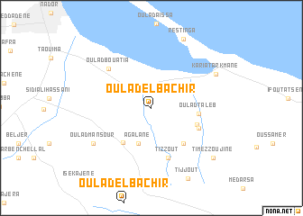
Oulad el Bachir (Nador, Morocco)Oulad el Bachir is a town in the Nador region of Morocco. An overview map of the region around Oulad el Bachir is displayed below.
regional and 3d topo map of Oulad el Bachir, Morocco ::
Oulad el Bachir airports ::
The nearest airport is MLN - Melilla, located 26.2 km north west of Oulad el Bachir.
Other airports nearby include OUD - Oujda Angads (87.7 km east), AHU - Al Hociema Cherif El Idrissi (93.7 km west), TLM - Tlemcen Zenata (125.0 km east), LEI - Almeria (200.7 km north), Nearby towns ::
Agalane (4.6km south) //
Ouled Ben Yahia (5.2km south west) //
Oulad Taleb (4.8km east) //
Oulad Kaddour ou Hamed (5.5km south east) //
Oulad Mohand (5.1km south east) //
Amar Teïmount (5.4km south east) //
Tizzout (6.5km south) //
Oulad Bouatia (6.5km north west) //
Oulad Mansour (7.3km south west) //
Kariat Arkmane (7.8km north east) //
Restinga (9.2km north) //
Tijjout (9.5km south east) //
Timezzoujine (8.8km south east) //
[all distances 'as the bird flies' and approximate]  Places with similar names to Oulad el Bachir, Morocco ::
// Oulad el Bachir (MA)
Disclaimer :: Information on this page comes without warranty of any kind |
||
|
Where is Oulad el Bachir? Elevation and coordinates ::
Latitude (lat): 35°4'22"N Longitude (lon): 2°49'8"W
Elevation (approx.): 60m (map arrows pan, magnifying glasses zoom) |
||
|
Visiting Oulad el Bachir? Hotel/Accommodation ::
Book a hotel in Oulad el Bachir Travel Guide ::
Buy a travel guide for Morocco rental cars ::
car rental offers GPS waypoint ::
download a GPX waypoint (PoI) of Oulad el Bachir for your GPS receiver
|
||