|
search place name
|
||
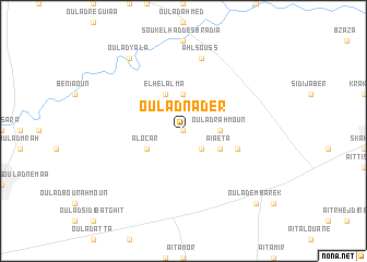
Oulad Nader (Beni Mellal, Morocco)Oulad Nader is a town in the Beni Mellal region of Morocco. An overview map of the region around Oulad Nader is displayed below.
regional and 3d topo map of Oulad Nader, Morocco ::
Oulad Nader airports ::
The nearest airport is CMN - Casablanca Mohammed V Intl, located 150.0 km north west of Oulad Nader.
Other airports nearby include OZZ - Ouarzazate (160.5 km south), RAK - Marrakech Menara (164.2 km south west), RBA - Rabat Sale (189.8 km north), MEK - Meknes Bassatine (194.4 km north east), Nearby towns ::
Oulad Nasser (0.0km north) //
Tebia (2.4km south east) //
Douar Oulad Driss (3.7km north) //
Oulad Rahmoun (3.1km east) //
Douar Souadeg (4.0km north west) //
El Helalma (4.0km north west) //
Aïaeta (3.6km south east) //
Al Ocar (3.6km south west) //
Ksar Day Oulad Embarek (5.0km east) //
Ahl Souss (7.6km north) //
Oulad Yala (8.8km north west) //
Oulad Embarek (9.7km south east) //
[all distances 'as the bird flies' and approximate]  Places with similar names to Oulad Nader, Morocco ::
// Oulad Antar (DZ)
Disclaimer :: Information on this page comes without warranty of any kind |
||
|
Where is Oulad Nader? Elevation and coordinates ::
Latitude (lat): 32°21'0"N Longitude (lon): 6°32'0"W
Elevation (approx.): 438m (map arrows pan, magnifying glasses zoom) |
||
|
Visiting Oulad Nader? Hotel/Accommodation ::
Book a hotel in Oulad Nader Travel Guide ::
Buy a travel guide for Morocco rental cars ::
car rental offers GPS waypoint ::
download a GPX waypoint (PoI) of Oulad Nader for your GPS receiver
|
||