|
search place name
|
||
Sidi Abd el Kader (Taroudannt, Morocco)Sidi Abd el Kader is a town in the Taroudannt region of Morocco. An overview map of the region around Sidi Abd el Kader is displayed below.
regional and 3d topo map of Sidi Abd el Kader, Morocco ::

Sidi Abd el Kader airports ::
The nearest airport is AGA - Agadir Inezgane, located 74.2 km west of Sidi Abd el Kader.
Other airports nearby include RAK - Marrakech Menara (143.5 km north east), OZZ - Ouarzazate (186.5 km east), Nearby towns ::
Freïja (0.0km north) //
Aït Yazza (2.4km north west) //
Sidi Yahia (3.7km north) //
Mharza (3.7km north) //
Oulad Arfa Ben Soussi (3.2km west) //
Aït Boubker (4.0km south west) //
Agadir Tolba (4.0km north east) //
Oulad Amira (3.7km south west) //
El Knassis (4.9km south west) //
Agadir Aït Cherki (4.8km east) //
Oulad Bou Ries (7.4km north east) //
Iahchech (8.1km south west) //
El Boura (8.5km north west) //
Oulad Terma (8.5km south west) //
Aït el Rhazi (9.8km north east) //
[all distances 'as the bird flies' and approximate] 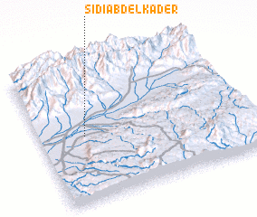 Places with similar names to Sidi Abd el Kader, Morocco ::
// Sīdī ‘Abd al Qādir (TN)
Disclaimer :: Information on this page comes without warranty of any kind |
||
|
Where is Sidi Abd el Kader? Elevation and coordinates ::
Latitude (lat): 30°29'0"N Longitude (lon): 8°47'0"W
Elevation (approx.): 266m (map arrows pan, magnifying glasses zoom) |
||
|
Visiting Sidi Abd el Kader? Hotel/Accommodation ::
Book a hotel in Sidi Abd el Kader Travel Guide ::
Buy a travel guide for Morocco rental cars ::
car rental offers GPS waypoint ::
download a GPX waypoint (PoI) of Sidi Abd el Kader for your GPS receiver
|
||