|
search place name
|
||
Sidi Omar (El Jadida, Morocco)Sidi Omar is a town in the El Jadida region of Morocco. An overview map of the region around Sidi Omar is displayed below.
regional and 3d topo map of Sidi Omar, Morocco ::

Sidi Omar airports ::
The nearest airport is RAK - Marrakech Menara, located 95.1 km south of Sidi Omar.
Other airports nearby include CMN - Casablanca Mohammed V Intl (128.1 km north east), OZZ - Ouarzazate (214.3 km south east), RBA - Rabat Sale (235.7 km north east), NNA - Kentira Kenitra (266.0 km north east), Nearby towns ::
Guerando (1.9km south) //
Cheïkh Ben Soltana (2.4km north west) //
Sidi Abdallah el Haouaoui (3.7km north) //
Seddik (3.6km south west) //
Oulad Mira (4.6km north) //
Oulad Ali (4.7km west) //
Ahl el Aïch (5.8km south) //
Sidi Ahmed ben Mbarka (6.0km south west) //
Mtal (7.3km north) //
El Hajj Larbi (6.7km south east) //
Rguibat (8.0km south east) //
El Haj el Hachmi (8.3km north west) //
Oulad Youssef (8.4km north west) //
El Orj (8.9km north west) //
[all distances 'as the bird flies' and approximate] 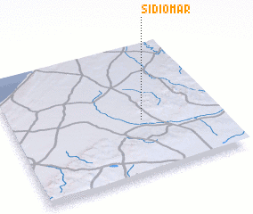 Places with similar names to Sidi Omar, Morocco ::
// Sudimiri (RU)
// Sidi Amar (MA)
// Sidi Amara (MA)
// Zhdimer (RU)
// Stomar (US)
// Seidmar (DE)
// Sottmar (DE)
// Stemmer (DE)
// Souto Maior (PT)
// Souto Maior (PT)
Disclaimer :: Information on this page comes without warranty of any kind |
||
|
Where is Sidi Omar? Elevation and coordinates ::
Latitude (lat): 32°25'0"N Longitude (lon): 8°22'0"W
Elevation (approx.): 347m (map arrows pan, magnifying glasses zoom) |
||
|
Visiting Sidi Omar? Hotel/Accommodation ::
Book a hotel in Sidi Omar Travel Guide ::
Buy a travel guide for Morocco rental cars ::
car rental offers GPS waypoint ::
download a GPX waypoint (PoI) of Sidi Omar for your GPS receiver
|
||