|
search place name
|
||
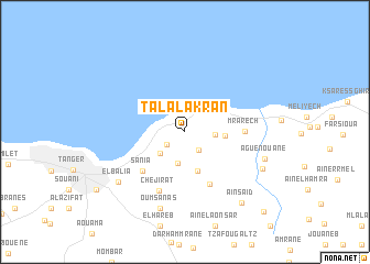
Tala Lakran (Tétouan, Morocco)Tala Lakran is a town in the Tétouan region of Morocco. An overview map of the region around Tala Lakran is displayed below.
regional and 3d topo map of Tala Lakran, Morocco ::
Tala Lakran airports ::
The nearest airport is TNG - Tanger Ibn Batouta, located 21.3 km south west of Tala Lakran.
Other airports nearby include TTU - Tetouan Saniat Rmel (43.3 km south east), GIB - Gibraltar (49.2 km north east), XRY - Jerez (107.3 km north), AGP - Malaga (144.5 km north east), Nearby towns ::
El Mnar (2.0km south west) //
Feddane Saïdi (2.2km south east) //
Talâa Cherif (2.5km east) //
Noûnouech (2.9km south west) //
Feddane Chappo (3.3km south) //
Khandak Zrarah (3.3km east) //
Aïn Zeïtoûria (4.1km south) //
Beni Mejmel (5.6km south) //
Sania (5.3km south west) //
Mrarech (4.9km east) //
Chejirat (6.4km south) //
Oumsanas (8.0km south) //
El Balia (7.5km south west) //
Aguenouane (7.1km south east) //
El Hammoumi (7.4km south east) //
Aïn Saïd (8.6km south east) //
Melloussa (10.4km south east) //
[all distances 'as the bird flies' and approximate] 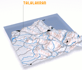 Places with similar names to Tala Lakran, Morocco :: Disclaimer :: Information on this page comes without warranty of any kind |
||
|
Where is Tala Lakran? Elevation and coordinates ::
Latitude (lat): 35°49'10"N Longitude (lon): 5°42'40"W
Elevation (approx.): 60m (map arrows pan, magnifying glasses zoom) |
||
|
Visiting Tala Lakran? Hotel/Accommodation ::
Book a hotel in Tala Lakran Travel Guide ::
Buy a travel guide for Morocco rental cars ::
car rental offers GPS waypoint ::
download a GPX waypoint (PoI) of Tala Lakran for your GPS receiver
|
||