|
search place name
|
||
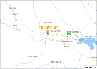
Tamassint (Ouarzazate, Morocco)Tamassint is a town in the Ouarzazate region of Morocco. An overview map of the region around Tamassint is displayed below.
regional and 3d topo map of Tamassint, Morocco ::
Tamassint airports ::
The nearest airport is OZZ - Ouarzazate, located 6.9 km east of Tamassint.
Other airports nearby include RAK - Marrakech Menara (125.1 km north west), Nearby towns ::
Isfoutalene (0.3km south west) //
Tifoultout (1.2km south west) //
Fedragount (1.4km east) //
Arhlane (2.0km south) //
Tagherramt (2.3km south east) //
Idkhissine (2.8km east) //
Zaouia Sidi Abd er Rahmane el Hajj (3.0km east) //
Tikniouine (3.6km north) //
Zaouiat Sidi Athmane (4.5km south east) //
Tassoumat (4.6km east) //
Inzebiatene (6.3km south east) //
Ouarzazat (6.2km east) //
Tabount (6.5km east) //
Iskhissane (7.3km south east) //
Tajda (7.9km south east) //
Tabount (8.4km south east) //
[all distances 'as the bird flies' and approximate] 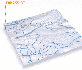 Places with similar names to Tamassint, Morocco ::
Disclaimer :: Information on this page comes without warranty of any kind |
||
|
Where is Tamassint? Elevation and coordinates ::
Latitude (lat): 30°56'5"N Longitude (lon): 6°58'52"W
Elevation (approx.): 1153m (map arrows pan, magnifying glasses zoom) |
||
|
Visiting Tamassint? Hotel/Accommodation ::
Book a hotel in Tamassint Travel Guide ::
Buy a travel guide for Morocco rental cars ::
car rental offers GPS waypoint ::
download a GPX waypoint (PoI) of Tamassint for your GPS receiver
|
||