|
search place name
|
||
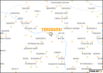
Tamgounsi (Essaouira, Morocco)Tamgounsi is a town in the Essaouira region of Morocco. An overview map of the region around Tamgounsi is displayed below.
regional and 3d topo map of Tamgounsi, Morocco ::
Tamgounsi airports ::
The nearest airport is AGA - Agadir Inezgane, located 90.6 km south of Tamgounsi.
Other airports nearby include RAK - Marrakech Menara (135.0 km east), Nearby towns ::
Agadir (1.9km south) //
Guemirs (1.6km east) //
Tamda Ifrane (1.9km north west) //
Zattaï (3.2km east) //
Ouargane (3.7km south west) //
Ibelay (3.7km south east) //
Embarek Ougadir (5.8km south) //
Afrad Ounejjar (6.0km south west) //
Ikhchachine (6.0km south west) //
Tlit (6.0km north east) //
Iferd Oumagour (6.0km north west) //
Tahellouant (6.4km north east) //
Tabout (7.2km south) //
Aït Lhassene (6.3km west) //
Bouferdou (7.6km south) //
Aït Ou Allal (6.6km west) //
Belmoudel (7.6km south) //
Tiguerout (6.6km east) //
Tagadirt Ou Rbaï (6.6km east) //
Tagarast (8.1km south west) //
Tagout (8.1km south east) //
Targoua (8.1km south east) //
Amskerkerd (8.1km north east) //
Tabelrhout (8.4km north west) //
Guerherdane (8.4km south west) //
Guedouane (8.4km south west) //
Tiourat (8.8km north east) //
Igoumane (8.8km north west) //
Tiouli (9.2km north west) //
[all distances 'as the bird flies' and approximate] 
Disclaimer :: Information on this page comes without warranty of any kind |
||
|
Where is Tamgounsi? Elevation and coordinates ::
Latitude (lat): 31°11'0"N Longitude (lon): 9°22'0"W
Elevation (approx.): 805m (map arrows pan, magnifying glasses zoom) |
||
|
Visiting Tamgounsi? Hotel/Accommodation ::
Book a hotel in Tamgounsi Travel Guide ::
Buy a travel guide for Morocco rental cars ::
car rental offers GPS waypoint ::
download a GPX waypoint (PoI) of Tamgounsi for your GPS receiver
|
||