|
search place name
|
||
Tasguint (Taroudannt, Morocco)Tasguint is a town in the Taroudannt region of Morocco. An overview map of the region around Tasguint is displayed below.
regional and 3d topo map of Tasguint, Morocco ::

Tasguint airports ::
The nearest airport is AGA - Agadir Inezgane, located 93.2 km south west of Tasguint.
Other airports nearby include RAK - Marrakech Menara (111.7 km north east), OZZ - Ouarzazate (170.7 km east), Nearby towns ::
Amzaourou (1.9km north) //
Aït Nasser (1.9km north) //
Targuent (2.4km south east) //
Tiguemmi Mkorn (3.7km south) //
Aoussir (3.7km south) //
Tagoudicht (3.7km north east) //
Addaza (3.7km south east) //
Iggui nʼOuakka (4.0km south east) //
Zawyat Bouchnine (4.9km south west) //
Talakjant (5.6km north) //
Igguia (5.1km east) //
Amerchene (5.8km north) //
Tikfilt (5.1km west) //
Figri (5.8km north) //
Yadar (6.4km south west) //
Tamsoult (7.4km south) //
Takoucht (6.6km east) //
Anzir (7.6km north) //
Issiguem (7.6km south) //
Aït Amer (8.1km south east) //
Adki (8.8km north east) //
Tissel (9.8km north east) //
Aït Hamid (9.8km south east) //
[all distances 'as the bird flies' and approximate] 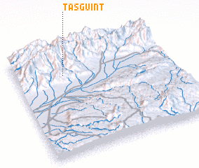 Places with similar names to Tasguint, Morocco ::
Disclaimer :: Information on this page comes without warranty of any kind |
||
|
Where is Tasguint? Elevation and coordinates ::
Latitude (lat): 30°46'0"N Longitude (lon): 8°41'0"W
Elevation (approx.): 1088m (map arrows pan, magnifying glasses zoom) |
||
|
Visiting Tasguint? Hotel/Accommodation ::
Book a hotel in Tasguint Travel Guide ::
Buy a travel guide for Morocco rental cars ::
car rental offers GPS waypoint ::
download a GPX waypoint (PoI) of Tasguint for your GPS receiver
|
||