|
search place name
|
||
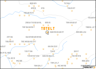
Tatelt (Agadir, Morocco)Tatelt is a town in the Agadir region of Morocco. An overview map of the region around Tatelt is displayed below.
regional and 3d topo map of Tatelt, Morocco ::
Tatelt airports ::
The nearest airport is AGA - Agadir Inezgane, located 52.4 km south west of Tatelt.
Other airports nearby include RAK - Marrakech Menara (151.5 km north east), Nearby towns ::
Ouamseguert (3.2km east) //
Ansis (3.7km north) //
Tounjimine (4.0km north west) //
Imi Irhzer (5.8km south) //
Iguer Bou Ahmed (5.1km west) //
Tamgousi (5.8km south) //
Zaouit Issoukal (6.0km north west) //
Tanoumrit (6.0km south west) //
Tikki (7.6km south) //
Tafougarht (6.6km west) //
Tachaoukecht (7.4km south west) //
Taguenza (9.8km north west) //
Tinftah (9.8km south west) //
Biramane (11.4km south east) //
[all distances 'as the bird flies' and approximate] 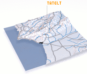 Places with similar names to Tatelt, Morocco ::
// Düte-Lada (DE)
// Dodlyt (US)
// Datilito (MX)
// Totolote (MX)
// Diataoulédou (GN)
// Tatelt (MA)
// Taïdalt (MA)
// Tʼedeletʼi (GE)
Disclaimer :: Information on this page comes without warranty of any kind |
||
|
Where is Tatelt? Elevation and coordinates ::
Latitude (lat): 30°49'0"N Longitude (lon): 9°20'0"W
Elevation (approx.): 1136m (map arrows pan, magnifying glasses zoom) |
||
|
Visiting Tatelt? Hotel/Accommodation ::
Book a hotel in Tatelt Travel Guide ::
Buy a travel guide for Morocco rental cars ::
car rental offers GPS waypoint ::
download a GPX waypoint (PoI) of Tatelt for your GPS receiver
|
||