|
search place name
|
||
Tiguissas (Agadir, Morocco)Tiguissas is a town in the Agadir region of Morocco. An overview map of the region around Tiguissas is displayed below.
regional and 3d topo map of Tiguissas, Morocco ::

Tiguissas airports ::
The nearest airport is AGA - Agadir Inezgane, located 77.6 km north west of Tiguissas.
Other airports nearby include RAK - Marrakech Menara (213.9 km north east), Nearby towns ::
Iggui nʼTaourirt (0.0km north) //
Tiguemmi Ouafa (1.9km north) //
Aït Ben Aïss (1.6km east) //
Amezdou Khsane (2.5km south west) //
Tamaïlt (2.5km south east) //
Tizourgane (3.7km north) //
Ifoullousene (3.7km north west) //
Tioulit (4.0km north west) //
Aguerd Imoul (4.0km south west) //
Ikhoullane (4.0km south east) //
Alma (5.2km west) //
Aït Iftene (6.1km south west) //
Outourouine (6.4km east) //
Madao (6.7km east) //
Tizi Gzaouine (6.7km east) //
Isli (7.4km south west) //
Aïoufis (7.4km north west) //
Ifrhel (8.1km north west) //
Agtel (7.4km south east) //
Tagmout (8.5km south east) //
Doudad (8.5km north west) //
[all distances 'as the bird flies' and approximate] 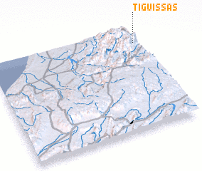 Places with similar names to Tiguissas, Morocco ::
Disclaimer :: Information on this page comes without warranty of any kind |
||
|
Where is Tiguissas? Elevation and coordinates ::
Latitude (lat): 29°52'0"N Longitude (lon): 9°0'0"W
Elevation (approx.): 1248m (map arrows pan, magnifying glasses zoom) |
||
|
Visiting Tiguissas? Hotel/Accommodation ::
Book a hotel in Tiguissas Travel Guide ::
Buy a travel guide for Morocco rental cars ::
car rental offers GPS waypoint ::
download a GPX waypoint (PoI) of Tiguissas for your GPS receiver
|
||