|
search place name
|
||
Alang (Nueva Vizcaya, Philippines)Alang is a town in the Nueva Vizcaya region of Philippines. An overview map of the region around Alang is displayed below.
regional and 3d topo map of Alang, Philippines ::

Alang airports ::
The nearest airport is BAG - Baguio, located 33.2 km north west of Alang.
Other airports nearby include MNL - Manila Ninoy Aquino Intl (189.6 km south), Nearby towns ::
Pacalbo (1.9km south) //
Gussadan (1.9km south) //
Talayao (1.9km south) //
Laneb (2.6km north east) //
Manged (2.6km south west) //
Alang (2.6km south east) //
Silao (3.6km east) //
Luglug (3.7km south) //
Antapoc (4.1km north west) //
Pisac (4.0km north west) //
Malico (4.1km south west) //
Baliling West (5.3km east) //
Gussadan (5.6km north) //
Patoctoc (5.7km east) //
Banet (5.8km north) //
Salacsac (6.6km south west) //
Palauglaug (6.6km north east) //
Talangcapao (6.6km north east) //
Imugan (6.8km south) //
Alupat (7.6km north) //
Yangiran (7.4km east) //
Calittacan (7.7km south east) //
Balangabang Small (8.2km north west) //
Palnet (8.2km north east) //
Gioong (8.0km north east) //
Calomingan (8.0km north east) //
Consuelo (8.0km south east) //
Santa Fe (8.5km south east) //
Kabalatan (8.8km north) //
[all distances 'as the bird flies' and approximate] 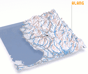 Places with similar names to Alang, Philippines ::
Disclaimer :: Information on this page comes without warranty of any kind |
||
|
Where is Alang? Elevation and coordinates ::
Latitude (lat): 16°13'0"N Longitude (lon): 120°53'0"E
Elevation (approx.): 1217m (map arrows pan, magnifying glasses zoom) |
||
|
Visiting Alang? Hotel/Accommodation ::
Book a hotel in Alang Travel Guide ::
Buy a travel guide for Philippines rental cars ::
car rental offers GPS waypoint ::
download a GPX waypoint (PoI) of Alang for your GPS receiver
|
||