|
search place name
|
||
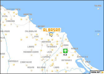
Albasan (Aklan, Philippines)Albasan is a town in the Aklan region of Philippines. An overview map of the region around Albasan is displayed below.
regional and 3d topo map of Albasan, Philippines ::
Albasan airports ::
The nearest airport is KLO - Kalibo, located 6.9 km south east of Albasan.
Other airports nearby include ILO - Iloilo (114.3 km south), SJI - San Jose Antique (114.7 km south), BCD - Bacolod (136.3 km south east), NOP - Masbate Mactan Cebu Intl (238.7 km south east), Nearby towns ::
Alba (0.9km north) //
Navitas (0.9km north) //
Madiang (1.0km south) //
Dongon (1.6km south west) //
Badio (2.0km north west) //
Camanci Norte (2.1km north east) //
Camanci Sur (2.2km east) //
Bubog (2.5km south east) //
Numancia (2.6km south) //
Bugasongan (2.8km south) //
San Roque (3.1km south east) //
Bulwang (3.1km east) //
Agcawilan (3.3km south west) //
Joyaojoyao (3.3km south west) //
Aliputos (3.3km south west) //
Ibao (3.3km south west) //
Tabangka (3.3km south west) //
Marianos (3.3km south west) //
Carugdug (3.3km south west) //
Mina (3.3km south west) //
Bagto (3.3km south west) //
Cogon (3.3km south west) //
Lagungbanua (3.3km south west) //
Cajilo (3.7km west) //
Kalibo (4.0km south east) //
Baybay (4.5km north west) //
Calangcang (4.6km south west) //
Santa Cruz (4.7km south) //
Nonok (4.7km south) //
[all distances 'as the bird flies' and approximate] 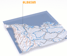 Places with similar names to Albasan, Philippines ::
Disclaimer :: Information on this page comes without warranty of any kind |
||
|
Where is Albasan? Elevation and coordinates ::
Latitude (lat): 11°43'31"N Longitude (lon): 122°19'59"E
Elevation (approx.): 11m (map arrows pan, magnifying glasses zoom) |
||
|
Visiting Albasan? Hotel/Accommodation ::
Book a hotel in Albasan Travel Guide ::
Buy a travel guide for Philippines rental cars ::
car rental offers GPS waypoint ::
download a GPX waypoint (PoI) of Albasan for your GPS receiver
|
||