|
search place name
|
||
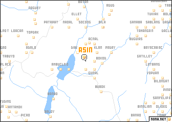
Asin (Benguet, Philippines)Asin is a town in the Benguet region of Philippines. An overview map of the region around Asin is displayed below.
regional and 3d topo map of Asin, Philippines ::
Asin airports ::
The nearest airport is BAG - Baguio, located 23.7 km south west of Asin.
Other airports nearby include MNL - Manila Ninoy Aquino Intl (221.6 km south), Nearby towns ::
Baload (1.9km south) //
Bangao (1.9km south) //
Bato (1.8km east) //
Inticak (2.6km south east) //
Dibang (2.6km north west) //
Daklan (3.0km north east) //
Bokod (3.4km east) //
Camangaan (3.7km north) //
Tiquey (4.1km north) //
Bolod (4.0km south west) //
Bunagan (4.1km north east) //
Acnal (4.1km north east) //
Gural (4.1km south east) //
Ambuclao (5.6km west) //
Carao (5.6km east) //
Chanom (5.6km east) //
Paday (5.6km east) //
Socong (7.4km north) //
Bubok (7.4km south east) //
Laboy (7.3km west) //
Naoal (8.2km north west) //
Apunan (8.2km north east) //
Bila (8.2km north east) //
Patapat (10.3km north west) //
Banao (10.8km south west) //
[all distances 'as the bird flies' and approximate]  Places with similar names to Asin, Philippines ::
Disclaimer :: Information on this page comes without warranty of any kind |
||
|
Where is Asin? Elevation and coordinates ::
Latitude (lat): 16°30'0"N Longitude (lon): 120°48'0"E
Elevation (approx.): 1093m (map arrows pan, magnifying glasses zoom) |
||
|
Visiting Asin? Hotel/Accommodation ::
Book a hotel in Asin Travel Guide ::
Buy a travel guide for Philippines rental cars ::
car rental offers GPS waypoint ::
download a GPX waypoint (PoI) of Asin for your GPS receiver
|
||