|
search place name
|
||
Bacalan (Antique, Philippines)Bacalan is a town in the Antique region of Philippines. An overview map of the region around Bacalan is displayed below.
regional and 3d topo map of Bacalan, Philippines ::

Bacalan airports ::
The nearest airport is KLO - Kalibo, located 34.7 km north east of Bacalan.
Other airports nearby include SJI - San Jose Antique (88.1 km south), ILO - Iloilo (105.0 km south east), BCD - Bacolod (135.9 km south east), NOP - Masbate Mactan Cebu Intl (248.1 km south east), Nearby towns ::
Aras-asan (2.2km south) //
Abiera (2.8km north) //
Alegre (2.8km south east) //
Tabaguen (3.7km south) //
Aguila (4.3km south) //
Sebaste (4.5km north) //
Pinatuad (5.3km south) //
Toledo (5.3km south) //
Libertad (5.3km south) //
Salde (5.4km south) //
Bitadton (6.1km south) //
Panaktakan (7.2km south) //
Simbola (7.8km south east) //
Naba (8.0km south) //
Idio (8.8km north) //
Galicia (9.3km east) //
[all distances 'as the bird flies' and approximate] 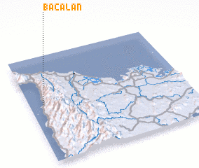 Places with similar names to Bacalan, Philippines ::
Disclaimer :: Information on this page comes without warranty of any kind |
||
|
Where is Bacalan? Elevation and coordinates ::
Latitude (lat): 11°32'51"N Longitude (lon): 122°5'16"E
Elevation (approx.): 72m (map arrows pan, magnifying glasses zoom) |
||
|
Visiting Bacalan? Hotel/Accommodation ::
Book a hotel in Bacalan Travel Guide ::
Buy a travel guide for Philippines rental cars ::
car rental offers GPS waypoint ::
download a GPX waypoint (PoI) of Bacalan for your GPS receiver
|
||