|
search place name
|
||
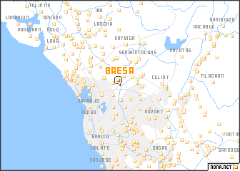
Baesa (Caloocan, Philippines)Baesa is a town in the Caloocan region of Philippines. An overview map of the region around Baesa is displayed below.
regional and 3d topo map of Baesa, Philippines ::
Baesa airports ::
The nearest airport is MNL - Manila Ninoy Aquino Intl, located 17.1 km south of Baesa.
Other airports nearby include BAG - Baguio (194.0 km north), Nearby towns ::
Tanque (1.1km west) //
Talipapa (1.7km north) //
Kangkong (1.8km south west) //
Balintawak (1.8km south west) //
Calaanan (1.8km south west) //
Banlat (2.2km north east) //
Masambong (2.3km south) //
Tullahan (2.3km north east) //
Santa Quiteria (2.5km north west) //
San Francisco del Monte (2.5km south east) //
Bahaytoro (2.6km east) //
Bahay Toro (2.8km east) //
Marulas (2.8km north west) //
Caloocan (3.0km west) //
Balongbato (3.2km south west) //
San Jose (3.2km south west) //
Maysilo (3.2km south west) //
Mahabang-gubat (3.2km south east) //
Bago Bantay (3.3km east) //
Tanque (3.4km south) //
Sapang Camias (3.5km south) //
Malitlit (3.5km south) //
Barilan (3.5km south) //
Malamig (3.5km south) //
Tandang Sora (3.4km north east) //
Quezon City (3.7km south east) //
Pasong Tamo (3.9km north east) //
Quigrande (4.1km north) //
Ugong (4.2km north) //
[all distances 'as the bird flies' and approximate]  Places with similar names to Baesa, Philippines ::
Disclaimer :: Information on this page comes without warranty of any kind |
||
|
Where is Baesa? Elevation and coordinates ::
Latitude (lat): 14°39'47"N Longitude (lon): 121°0'35"E
Elevation (approx.): 27m (map arrows pan, magnifying glasses zoom) |
||
|
Visiting Baesa? Hotel/Accommodation ::
Book a hotel in Baesa Travel Guide ::
Buy a travel guide for Philippines rental cars ::
car rental offers GPS waypoint ::
download a GPX waypoint (PoI) of Baesa for your GPS receiver
|
||