|
search place name
|
||
Baling (Ilocos Sur, Philippines)Baling is a town in the Ilocos Sur region of Philippines. An overview map of the region around Baling is displayed below.
regional and 3d topo map of Baling, Philippines ::

Baling airports ::
The nearest airport is BAG - Baguio, located 82.6 km south of Baling.
Nearby towns ::
Villa Hermosa (0.0km north) //
Nangalisan (0.0km north) //
Baybay (1.9km south) //
Bao-as (2.6km north east) //
Damacuag (2.6km north east) //
Buliclic (2.6km north east) //
Conconig (2.6km north east) //
Sapang (2.6km north east) //
Vical (2.6km north east) //
Nagrebcan (2.6km north east) //
Palali Norte (2.6km north east) //
Palali Sur (2.6km north east) //
Banbanaba (2.6km north east) //
Ar-aro (2.6km north east) //
Ronda (2.6km north east) //
Lobung (2.6km north east) //
Pila (2.6km north east) //
Quinabalayangan (2.6km north east) //
Alincaoeg (2.6km north east) //
Paratong (2.6km north east) //
Suagayan (2.6km north east) //
Pilar-Baybay (2.6km south east) //
Lantag (2.6km south east) //
Gabor Sur (2.6km south east) //
Gabor Norte (2.6km south east) //
Mambog (2.6km south east) //
Babayoan (2.6km south east) //
Cabaroan (2.6km south east) //
Quenfermin (2.6km south east) //
[all distances 'as the bird flies' and approximate] 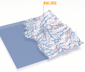 Places with similar names to Baling, Philippines ::
Disclaimer :: Information on this page comes without warranty of any kind |
||
|
Where is Baling? Elevation and coordinates ::
Latitude (lat): 17°6'0"N Longitude (lon): 120°26'0"E
Elevation (approx.): -32768m (map arrows pan, magnifying glasses zoom) |
||
|
Visiting Baling? Hotel/Accommodation ::
Book a hotel in Baling Travel Guide ::
Buy a travel guide for Philippines rental cars ::
car rental offers GPS waypoint ::
download a GPX waypoint (PoI) of Baling for your GPS receiver
|
||