|
search place name
|
||
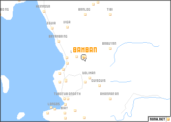
Bamban (Pangasinan, Philippines)Bamban is a town in the Pangasinan region of Philippines. An overview map of the region around Bamban is displayed below.
regional and 3d topo map of Bamban, Philippines ::
Bamban airports ::
The nearest airport is BAG - Baguio, located 92.8 km north east of Bamban.
Other airports nearby include MNL - Manila Ninoy Aquino Intl (186.9 km south east), Nearby towns ::
Lambes (0.9km north) //
Layas (2.1km north west) //
Dororui (2.1km north west) //
Doliman (3.8km south) //
Cato (3.8km west) //
Cato (4.0km west) //
Lomboy (4.6km south) //
Infanta (5.0km west) //
Gama (5.9km south west) //
Babuyan (5.9km north east) //
Malabago (6.0km south west) //
Guisguis (6.1km south east) //
San Juan (6.1km south west) //
Nayom (6.1km south west) //
Bayambang (7.1km north west) //
Pamloran (7.1km south west) //
Viga (8.4km north west) //
Naulo (9.1km south west) //
Tubotubo North (9.1km south west) //
San Fernando (9.1km south west) //
Santa Cruz (9.4km south west) //
Amanparan (9.9km south east) //
Eguia (10.0km north west) //
[all distances 'as the bird flies' and approximate] 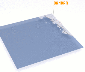 Places with similar names to Bamban, Philippines ::
Disclaimer :: Information on this page comes without warranty of any kind |
||
|
Where is Bamban? Elevation and coordinates ::
Latitude (lat): 15°50'30"N Longitude (lon): 119°57'3"E
Elevation (approx.): 33m (map arrows pan, magnifying glasses zoom) |
||
|
Visiting Bamban? Hotel/Accommodation ::
Book a hotel in Bamban Travel Guide ::
Buy a travel guide for Philippines rental cars ::
car rental offers GPS waypoint ::
download a GPX waypoint (PoI) of Bamban for your GPS receiver
|
||