|
search place name
|
||
Bantud (Iloilo, Philippines)Bantud is a town in the Iloilo region of Philippines. An overview map of the region around Bantud is displayed below.
regional and 3d topo map of Bantud, Philippines ::

Bantud airports ::
The nearest airport is ILO - Iloilo, located 16.0 km south west of Bantud.
Other airports nearby include BCD - Bacolod (35.1 km south east), SJI - San Jose Antique (79.1 km west), KLO - Kalibo (101.1 km north), NOP - Masbate Mactan Cebu Intl (155.1 km east), Nearby towns ::
Tubigan (1.1km south west) //
Patahan (1.1km south west) //
Talauguis (1.1km south west) //
Cayos (1.4km north west) //
Sulangan (1.5km south east) //
Buncal (2.6km west) //
Lipongogen (2.6km west) //
Compayan (2.6km west) //
Pasil (2.8km north west) //
Maquina (2.8km north) //
Patlad (3.2km east) //
Balud (3.7km north west) //
Parasoan (3.8km south west) //
Sulangan (4.3km north east) //
Pangpang (4.3km west) //
Balabag (4.5km north) //
Tabucan (4.7km north) //
Jalauod (4.7km north) //
Bungco (4.7km north) //
Pagdugue (4.8km north) //
Dacutan (4.8km east) //
Baras (4.9km east) //
Gua-an (5.1km south west) //
Gines (5.1km north west) //
Zarraga (5.3km west) //
Cansilayan (5.5km north east) //
Cali (5.6km north east) //
Bitaog (6.0km north west) //
Cagamutan Norte (6.1km west) //
[all distances 'as the bird flies' and approximate] 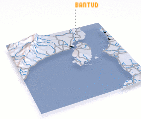 Places with similar names to Bantud, Philippines ::
Disclaimer :: Information on this page comes without warranty of any kind |
||
|
Where is Bantud? Elevation and coordinates ::
Latitude (lat): 10°48'30"N Longitude (lon): 122°39'20"E
Elevation (approx.): 6m (map arrows pan, magnifying glasses zoom) |
||
|
Visiting Bantud? Hotel/Accommodation ::
Book a hotel in Bantud Travel Guide ::
Buy a travel guide for Philippines rental cars ::
car rental offers GPS waypoint ::
download a GPX waypoint (PoI) of Bantud for your GPS receiver
|
||