|
search place name
|
||
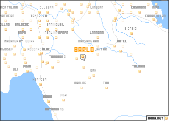
Barlo (Pangasinan, Philippines)Barlo is a town in the Pangasinan region of Philippines. An overview map of the region around Barlo is displayed below.
regional and 3d topo map of Barlo, Philippines ::
Barlo airports ::
The nearest airport is BAG - Baguio, located 82.8 km north east of Barlo.
Other airports nearby include MNL - Manila Ninoy Aquino Intl (199.6 km south east), Nearby towns ::
Caliwaing (1.5km south) //
Baknit (1.7km west) //
Ngibngib (3.2km north east) //
Tinalaktak (3.2km north east) //
Cabulao (3.4km north) //
Nansangaan (3.4km north) //
Gak (3.9km south east) //
Mambao (3.9km south) //
Balite (4.3km north east) //
Tanobong (5.6km west) //
Laragan (5.8km north east) //
Banlog (6.1km south) //
Malimpin (6.9km west) //
Santa Rita (7.4km north) //
Trozo (7.2km north east) //
Tibi (7.6km south east) //
Masalimpapapa (7.9km north west) //
Mandapot (7.9km west) //
Guilbert (7.9km east) //
Dasol (8.3km west) //
Bacnit (8.8km north) //
Amakalan (8.8km east) //
Watel (8.8km east) //
Nabaleo (9.1km north) //
Cabinuangan (9.1km north) //
San Miguel (9.2km north west) //
San Pascual (9.3km north west) //
Viga (9.8km south west) //
Littaong (10.5km north west) //
[all distances 'as the bird flies' and approximate] 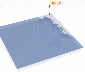 Places with similar names to Barlo, Philippines ::
Disclaimer :: Information on this page comes without warranty of any kind |
||
|
Where is Barlo? Elevation and coordinates ::
Latitude (lat): 15°59'16"N Longitude (lon): 119°57'24"E
Elevation (approx.): 62m (map arrows pan, magnifying glasses zoom) |
||
|
Visiting Barlo? Hotel/Accommodation ::
Book a hotel in Barlo Travel Guide ::
Buy a travel guide for Philippines rental cars ::
car rental offers GPS waypoint ::
download a GPX waypoint (PoI) of Barlo for your GPS receiver
|
||