|
search place name
|
||
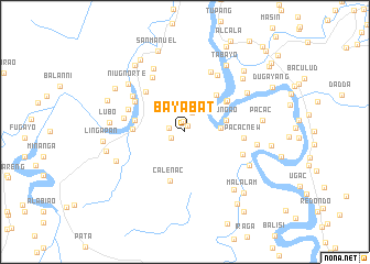
Bayabat (Cagayan, Philippines)Bayabat is a town in the Cagayan region of Philippines. An overview map of the region around Bayabat is displayed below.
regional and 3d topo map of Bayabat, Philippines ::
Bayabat airports ::
The nearest airport is BAG - Baguio, located 191.9 km south west of Bayabat.
Nearby towns ::
Punta (0.6km north east) //
Abbeg Sur (1.1km north) //
Baygabor (1.5km south west) //
Bacring (1.5km west) //
Abbeg (2.1km north) //
Cabaruan (3.4km east) //
Dungao (4.1km east) //
Afusing Daga (4.8km north east) //
Lanna (5.0km north east) //
Calenac (5.2km south) //
Macical (5.0km west) //
Tabang (5.0km west) //
Afusing Batu (5.2km north east) //
Palusao (5.6km north west) //
Masical (5.7km north west) //
Pacac New (5.8km east) //
Niug Sur (5.9km north west) //
Annafatan (6.0km east) //
San Roque (6.2km north west) //
Lattac (6.1km west) //
Mabitbitnong (6.3km north west) //
Malalatan (6.5km north east) //
Tamban (6.6km north) //
Sidiran (7.1km north west) //
Palayag (7.0km east) //
Casinsingan (7.1km south east) //
Niug Norte (7.3km north west) //
Gabut (7.3km north east) //
Namay (7.3km south west) //
[all distances 'as the bird flies' and approximate] 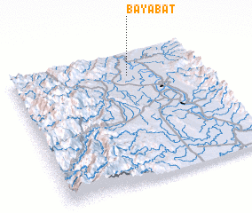 Places with similar names to Bayabat, Philippines ::
Disclaimer :: Information on this page comes without warranty of any kind |
||
|
Where is Bayabat? Elevation and coordinates ::
Latitude (lat): 17°49'21"N Longitude (lon): 121°36'45"E
Elevation (approx.): 23m (map arrows pan, magnifying glasses zoom) |
||
|
Visiting Bayabat? Hotel/Accommodation ::
Book a hotel in Bayabat Travel Guide ::
Buy a travel guide for Philippines rental cars ::
car rental offers GPS waypoint ::
download a GPX waypoint (PoI) of Bayabat for your GPS receiver
|
||