|
search place name
|
||
Bayang (Northern Samar, Philippines)Bayang is a town in the Northern Samar region of Philippines. An overview map of the region around Bayang is displayed below.
regional and 3d topo map of Bayang, Philippines ::

Bayang airports ::
The nearest airport is TAC - Tacloban Daniel Z Romualdez, located 157.3 km south east of Bayang.
Other airports nearby include BCD - Bacolod (261.4 km south west), ILO - Iloilo (283.4 km south west), Nearby towns ::
Calpi (2.0km south west) //
Senimangan (2.0km south west) //
Multo (2.1km north east) //
San Miguel (2.3km north) //
Enriqueta (2.8km north) //
Rosario (3.2km north east) //
Sumisip (3.7km west) //
Busay (3.7km west) //
Jamo-og (4.0km north) //
Urdaneta (5.8km north west) //
Borabaybay (6.0km north west) //
Buenavista (6.1km north east) //
Libertad (7.3km west) //
Bunglasan (7.4km south west) //
Manlicolico (7.7km west) //
Lavezares (8.0km west) //
Bani (8.5km north west) //
Cagabaca (8.9km south west) //
San Roman (9.9km south west) //
Acedillo (10.1km south west) //
Taboc (11.4km south west) //
[all distances 'as the bird flies' and approximate] 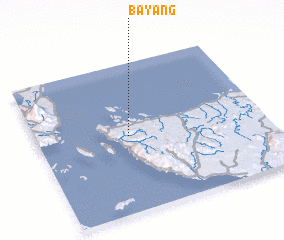 Places with similar names to Bayang, Philippines ::
Disclaimer :: Information on this page comes without warranty of any kind |
||
|
Where is Bayang? Elevation and coordinates ::
Latitude (lat): 12°30'30"N Longitude (lon): 124°23'59"E
Elevation (approx.): 26m (map arrows pan, magnifying glasses zoom) |
||
|
Visiting Bayang? Hotel/Accommodation ::
Book a hotel in Bayang Travel Guide ::
Buy a travel guide for Philippines rental cars ::
car rental offers GPS waypoint ::
download a GPX waypoint (PoI) of Bayang for your GPS receiver
|
||