|
search place name
|
||
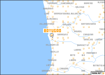
Bayugao (Ilocos Sur, Philippines)Bayugao is a town in the Ilocos Sur region of Philippines. An overview map of the region around Bayugao is displayed below.
regional and 3d topo map of Bayugao, Philippines ::
Bayugao airports ::
The nearest airport is BAG - Baguio, located 78.6 km south of Bayugao.
Nearby towns ::
Pinipin (0.5km south) //
Sagat (1.6km south east) //
Mambog (1.9km north) //
Quenfermin (1.9km north) //
Gabor Norte (1.9km north) //
Tampugo (1.9km north) //
Coscosnong (1.9km north) //
Quenquibol (1.9km north) //
Quensoriano (1.9km north) //
Babayoan (1.9km north) //
San Antonio (1.9km north) //
Mantanas (1.9km north) //
Gabor Sur (1.9km north) //
Cabaroan (1.9km north) //
Lantag (1.9km north) //
Pilar-Baybay (1.9km north) //
Calaoaan (1.9km north) //
Casilagan (1.9km north) //
Turod (1.8km east) //
Bacsayan (1.8km east) //
Santa Cruz (2.1km north) //
Baybay (2.6km north west) //
Nagtengga (2.6km south east) //
San Pedro (3.5km east) //
Cabulalaan (3.5km east) //
Villa Garcia (3.7km south) //
Dili (3.7km south) //
Capariaan (3.7km south) //
Amarao (3.8km east) //
[all distances 'as the bird flies' and approximate]  Places with similar names to Bayugao, Philippines ::
Disclaimer :: Information on this page comes without warranty of any kind |
||
|
Where is Bayugao? Elevation and coordinates ::
Latitude (lat): 17°4'0"N Longitude (lon): 120°27'0"E
Elevation (approx.): 4m (map arrows pan, magnifying glasses zoom) |
||
|
Visiting Bayugao? Hotel/Accommodation ::
Book a hotel in Bayugao Travel Guide ::
Buy a travel guide for Philippines rental cars ::
car rental offers GPS waypoint ::
download a GPX waypoint (PoI) of Bayugao for your GPS receiver
|
||