|
search place name
|
||
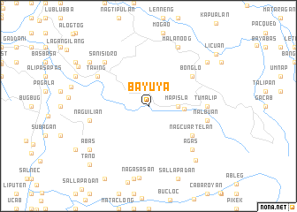
Bayuya (Abra, Philippines)Bayuya is a town in the Abra region of Philippines. An overview map of the region around Bayuya is displayed below.
regional and 3d topo map of Bayuya, Philippines ::
Bayuya airports ::
The nearest airport is BAG - Baguio, located 132.0 km south of Bayuya.
Nearby towns ::
Mapisla (3.5km east) //
Magang (3.5km east) //
Ba-ay (4.4km east) //
Bonglo (6.5km north east) //
Nagcuartelan (6.5km south east) //
Tawing (7.2km north west) //
Tumalip (7.1km east) //
Naguilian (7.3km west) //
Nalbuan (7.3km east) //
Agas (7.7km south east) //
San Isidro (7.7km north west) //
Malanoog (8.2km north east) //
Caoayan (8.2km north east) //
Agasasan (8.9km south east) //
Paoa (9.0km north west) //
Abas (9.0km south west) //
Bangong (9.0km north east) //
Gaoayan (9.0km north east) //
Tagodtod (9.8km north west) //
Tano (10.2km south west) //
Licuan (10.4km north east) //
[all distances 'as the bird flies' and approximate] 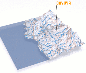 Places with similar names to Bayuya, Philippines ::
Disclaimer :: Information on this page comes without warranty of any kind |
||
|
Where is Bayuya? Elevation and coordinates ::
Latitude (lat): 17°33'0"N Longitude (lon): 120°50'0"E
Elevation (approx.): 298m (map arrows pan, magnifying glasses zoom) |
||
|
Visiting Bayuya? Hotel/Accommodation ::
Book a hotel in Bayuya Travel Guide ::
Buy a travel guide for Philippines rental cars ::
car rental offers GPS waypoint ::
download a GPX waypoint (PoI) of Bayuya for your GPS receiver
|
||