|
search place name
|
||
Belen (Iloilo, Philippines)Belen is a town in the Iloilo region of Philippines. An overview map of the region around Belen is displayed below.
regional and 3d topo map of Belen, Philippines ::

Belen airports ::
The nearest airport is ILO - Iloilo, located 34.8 km east of Belen.
Other airports nearby include SJI - San Jose Antique (35.2 km west), BCD - Bacolod (76.2 km east), KLO - Kalibo (114.9 km north), DGT - Dumaguete (186.8 km south east), Nearby towns ::
Igpuro (0.0km north) //
Igsoligue (0.0km north) //
Igpangdan (0.0km north) //
Igpajo (0.0km north) //
Caitib (0.0km north) //
Igdalaquit (0.0km north) //
Diday (0.0km north) //
Guibuñgan (0.0km north) //
Igcatambor (0.0km north) //
Igdulaca (0.0km north) //
Gines (0.0km north) //
Frantilla (0.0km north) //
Calagtañgan (0.0km north) //
Igbita (0.0km north) //
Bolocaue (0.0km north) //
Bagumbayan (0.0km north) //
Bacauan (0.0km north) //
Buenavista (0.0km north) //
Dalite (0.0km north) //
Cubay (0.0km north) //
Bugtong Lamangan (0.0km north) //
Igbugo (0.0km north) //
Cabala-unan (0.0km north) //
Cabang (0.0km north) //
Cabangcalan (0.0km north) //
Dingle (0.0km north) //
Cadoldolan (0.0km north) //
Indag-an (0.0km north) //
Ilog-ilog (0.0km north) //
[all distances 'as the bird flies' and approximate] 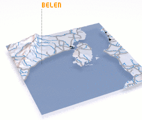 Places with similar names to Belen, Philippines ::
Disclaimer :: Information on this page comes without warranty of any kind |
||
|
Where is Belen? Elevation and coordinates ::
Latitude (lat): 10°39'0"N Longitude (lon): 122°14'0"E
Elevation (approx.): 14m (map arrows pan, magnifying glasses zoom) |
||
|
Visiting Belen? Hotel/Accommodation ::
Book a hotel in Belen Travel Guide ::
Buy a travel guide for Philippines rental cars ::
car rental offers GPS waypoint ::
download a GPX waypoint (PoI) of Belen for your GPS receiver
|
||