|
search place name
|
||
Botao (Pangasinan, Philippines)Botao is a town in the Pangasinan region of Philippines. An overview map of the region around Botao is displayed below.
regional and 3d topo map of Botao, Philippines ::

Botao airports ::
The nearest airport is BAG - Baguio, located 51.0 km north of Botao.
Other airports nearby include MNL - Manila Ninoy Aquino Intl (168.7 km south), Nearby towns ::
Tabo-Sili (0.7km south west) //
Taloy (1.5km north) //
Taloyan (1.5km north) //
Lunec (1.9km north east) //
Bobon (2.3km west) //
Calbueg (2.7km north west) //
Talospatang (3.1km south west) //
Mangan Dampay (3.1km east) //
Calbueg (3.3km north) //
Agdao (3.3km south west) //
Dilasup (3.3km south west) //
Nagsangaan (3.3km south west) //
Bacundao Weste (3.8km south east) //
Carusucan (4.0km north west) //
Cablong (4.0km north west) //
Bolaoit (4.0km west) //
Cabog (4.1km west) //
Canan Norte (4.4km south) //
Lokeb (4.3km west) //
Aliaga (4.8km south west) //
Malimpec (4.8km south west) //
Catablan (5.1km north) //
Minien Este (5.0km north east) //
Tebag (5.1km north) //
Lareglareg (5.2km south east) //
Bansal (5.6km north west) //
Patayac (5.5km north west) //
Lepa (5.8km south west) //
Agdao (5.8km south west) //
[all distances 'as the bird flies' and approximate] 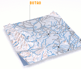 Places with similar names to Botao, Philippines ::
Disclaimer :: Information on this page comes without warranty of any kind |
||
|
Where is Botao? Elevation and coordinates ::
Latitude (lat): 15°56'15"N Longitude (lon): 120°28'17"E
Elevation (approx.): 30m (map arrows pan, magnifying glasses zoom) |
||
|
Visiting Botao? Hotel/Accommodation ::
Book a hotel in Botao Travel Guide ::
Buy a travel guide for Philippines rental cars ::
car rental offers GPS waypoint ::
download a GPX waypoint (PoI) of Botao for your GPS receiver
|
||