|
search place name
|
||
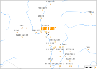
Buntuan (Kalinga-Apayao, Philippines)Buntuan is a town in the Kalinga-Apayao region of Philippines. An overview map of the region around Buntuan is displayed below.
regional and 3d topo map of Buntuan, Philippines ::
Buntuan airports ::
The nearest airport is BAG - Baguio, located 212.0 km south of Buntuan.
Nearby towns ::
Nabuccayan (1.2km north west) //
Lubung (1.3km south east) //
Talisian (1.5km south west) //
Asset (1.5km south west) //
Alinasan (2.1km north west) //
Darras (2.8km north) //
Tabangan (2.9km west) //
Calanasan (3.0km north west) //
Nabacayan (3.9km south east) //
Daligan (4.4km south) //
Aoan (4.6km west) //
Apaguen (4.6km west) //
Bakul (5.4km south east) //
Enganga (5.6km south) //
Pagpagudan (6.4km south east) //
Dalawas (6.7km south) //
Banan (6.9km north west) //
Talakpat (7.2km south east) //
Aliuniun (7.9km south east) //
Buteg (7.9km south east) //
Langnao (7.9km south east) //
Liniun (7.9km south east) //
Talibubu (7.9km south east) //
Lalun (8.5km west) //
Awan (8.5km west) //
Nabonagan (9.5km south east) //
Bogtong (10.2km south east) //
Papaoar (10.4km south east) //
Tuung (11.5km south east) //
[all distances 'as the bird flies' and approximate]  Places with similar names to Buntuan, Philippines ::
Disclaimer :: Information on this page comes without warranty of any kind |
||
|
Where is Buntuan? Elevation and coordinates ::
Latitude (lat): 18°14'36"N Longitude (lon): 121°3'36"E
Elevation (approx.): 361m (map arrows pan, magnifying glasses zoom) |
||
|
Visiting Buntuan? Hotel/Accommodation ::
Book a hotel in Buntuan Travel Guide ::
Buy a travel guide for Philippines rental cars ::
car rental offers GPS waypoint ::
download a GPX waypoint (PoI) of Buntuan for your GPS receiver
|
||