|
search place name
|
||
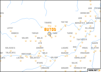
Butod (Kalinga-Apayao, Philippines)Butod is a town in the Kalinga-Apayao region of Philippines. An overview map of the region around Butod is displayed below.
regional and 3d topo map of Butod, Philippines ::
Butod airports ::
The nearest airport is BAG - Baguio, located 147.2 km south west of Butod.
Nearby towns ::
Buaya (0.0km north) //
Balawag (0.6km south east) //
Baguang (1.8km west) //
Tuod (1.8km east) //
Madadnaaw (1.8km east) //
Lumuasan (3.7km north) //
Tawang (3.9km north) //
Balio (4.0km south west) //
Magnagay (4.1km north east) //
Bulac (4.5km north east) //
Tapuc (4.6km north west) //
Canao (5.1km south west) //
Uta (5.1km south west) //
Tapiun (5.3km west) //
Rubatub (5.3km west) //
Balala (5.6km west) //
Obual (5.9km south west) //
Gawaan (6.6km south west) //
Asiga (6.5km north east) //
Diyungan (6.5km north east) //
Toctoc (6.6km north east) //
Tupac (7.1km east) //
Gumogdog (7.3km west) //
Bolo (7.6km south) //
Gollod (7.3km east) //
Dusoc (7.6km south west) //
Luguac (7.7km south east) //
Alingag (8.2km south west) //
Pusa (8.2km south west) //
[all distances 'as the bird flies' and approximate] 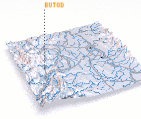 Places with similar names to Butod, Philippines ::
Disclaimer :: Information on this page comes without warranty of any kind |
||
|
Where is Butod? Elevation and coordinates ::
Latitude (lat): 17°34'0"N Longitude (lon): 121°14'0"E
Elevation (approx.): 689m (map arrows pan, magnifying glasses zoom) |
||
|
Visiting Butod? Hotel/Accommodation ::
Book a hotel in Butod Travel Guide ::
Buy a travel guide for Philippines rental cars ::
car rental offers GPS waypoint ::
download a GPX waypoint (PoI) of Butod for your GPS receiver
|
||