|
search place name
|
||
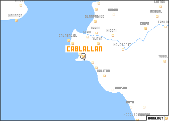
Cablallan (South Cotabato, Philippines)Cablallan is a town in the South Cotabato region of Philippines. An overview map of the region around Cablallan is displayed below.
regional and 3d topo map of Cablallan, Philippines ::
Cablallan airports ::
The nearest airport is CEB - Cebu Cotabato, located 188.5 km north west of Cablallan.
Nearby towns ::
Gumasa (1.5km north west) //
Kapala (1.8km east) //
Sinabulad (3.1km north west) //
Calimbega (3.1km south east) //
Taluya (4.6km north west) //
Ylaya (4.9km north east) //
Glan (5.2km north) //
Baliton (5.5km south east) //
Calabalol (5.6km north west) //
Tapon (6.6km north east) //
Kiogam (8.4km north east) //
Kalabanit (8.8km east) //
Glan-Padido (8.9km north) //
Burias (9.1km south east) //
Punsad (11.0km south east) //
[all distances 'as the bird flies' and approximate] 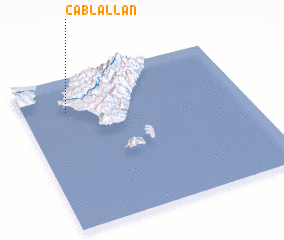 Places with similar names to Cablallan, Philippines ::
// Cabolalaan (PH)
// Cabolalaan (PH)
// Cabulalaan (PH)
// Cabulalaan (PH)
// Cabulalaan (PH)
// Cabulalaan (PH)
// Cabulalaon (PH)
// Cabulalo-an (PH)
Disclaimer :: Information on this page comes without warranty of any kind |
||
|
Where is Cablallan? Elevation and coordinates ::
Latitude (lat): 5°46'36"N Longitude (lon): 125°11'53"E
Elevation (approx.): 64m (map arrows pan, magnifying glasses zoom) |
||
|
Visiting Cablallan? Hotel/Accommodation ::
Book a hotel in Cablallan Travel Guide ::
Buy a travel guide for Philippines rental cars ::
car rental offers GPS waypoint ::
download a GPX waypoint (PoI) of Cablallan for your GPS receiver
|
||