|
search place name
|
||
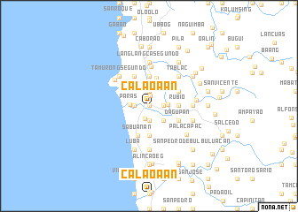
Calaoaan (Ilocos Sur, Philippines)Calaoaan is a town in the Ilocos Sur region of Philippines. An overview map of the region around Calaoaan is displayed below.
regional and 3d topo map of Calaoaan, Philippines ::
Calaoaan airports ::
The nearest airport is BAG - Baguio, located 91.3 km south of Calaoaan.
Nearby towns ::
Oaig Daya (0.0km north) //
Candon (1.3km north) //
Ayudante (1.7km south) //
Tangadan (1.9km south) //
Salvador Primero (1.9km north) //
Calongbuyan (1.9km north) //
San Pedro (1.9km north) //
San Andres (1.9km north) //
Talogtog (1.9km north) //
Cucubbuot (1.9km north) //
San Juan (1.9km north) //
San Nicolas (1.9km north) //
Santo Tomas (1.9km north) //
Amguid (1.9km north) //
Abaya (1.8km east) //
Kilang (1.8km east) //
Bidbiday (1.8km east) //
Calongbuyan (1.8km east) //
Patpata Primero (1.8km west) //
Matanubong (1.8km east) //
Paypayad (1.8km west) //
Patpata Segundo (1.8km west) //
Sabañgan Bato (1.8km east) //
Loco (1.8km east) //
Sacaang (1.8km east) //
Bitong (1.8km east) //
Bagani (2.3km north) //
Paras (2.2km west) //
Galimuyod (2.3km east) //
[all distances 'as the bird flies' and approximate]  Places with similar names to Calaoaan, Philippines ::
Disclaimer :: Information on this page comes without warranty of any kind |
||
|
Where is Calaoaan? Elevation and coordinates ::
Latitude (lat): 17°11'0"N Longitude (lon): 120°27'0"E
Elevation (approx.): 11m (map arrows pan, magnifying glasses zoom) |
||
|
Visiting Calaoaan? Hotel/Accommodation ::
Book a hotel in Calaoaan Travel Guide ::
Buy a travel guide for Philippines rental cars ::
car rental offers GPS waypoint ::
download a GPX waypoint (PoI) of Calaoaan for your GPS receiver
|
||