|
search place name
|
||
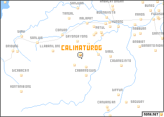
Calimaturog (Quirino, Philippines)Calimaturog is a town in the Quirino region of Philippines. An overview map of the region around Calimaturog is displayed below.
regional and 3d topo map of Calimaturog, Philippines ::
Calimaturog airports ::
The nearest airport is BAG - Baguio, located 96.9 km west of Calimaturog.
Nearby towns ::
Diffun (2.2km south east) //
Lukban (2.3km south west) //
Sinappil (3.3km north east) //
Baday (3.6km north east) //
Gulac (3.7km east) //
Cabarroguis (3.9km south) //
Gayongayong (4.1km north) //
Bayug (6.0km north east) //
Dibul (6.3km east) //
Capaltitan (6.6km north east) //
Llaban Ilongot (6.6km west) //
Cordon (6.9km north west) //
Burahit (7.0km north east) //
Patul (7.3km north east) //
Cadaanan (7.8km north) //
Malapat (8.2km north) //
Dubinan (9.6km north east) //
Calao (9.6km north east) //
Santiago (10.3km north east) //
Murong (10.8km north east) //
Diffun (11.5km south east) //
[all distances 'as the bird flies' and approximate] 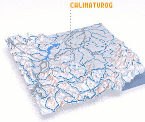 Places with similar names to Calimaturog, Philippines ::
// Kilómetro 20 (CO)
// Kilómetro 86 (HN)
Disclaimer :: Information on this page comes without warranty of any kind |
||
|
Where is Calimaturog? Elevation and coordinates ::
Latitude (lat): 16°37'4"N Longitude (lon): 121°29'31"E
Elevation (approx.): 125m (map arrows pan, magnifying glasses zoom) |
||
|
Visiting Calimaturog? Hotel/Accommodation ::
Book a hotel in Calimaturog Travel Guide ::
Buy a travel guide for Philippines rental cars ::
car rental offers GPS waypoint ::
download a GPX waypoint (PoI) of Calimaturog for your GPS receiver
|
||