|
search place name
|
||
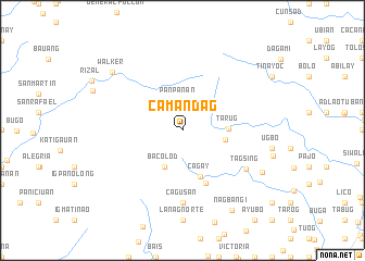
Camandag (Iloilo, Philippines)Camandag is a town in the Iloilo region of Philippines. An overview map of the region around Camandag is displayed below.
regional and 3d topo map of Camandag, Philippines ::
Camandag airports ::
The nearest airport is ILO - Iloilo, located 35.8 km south east of Camandag.
Other airports nearby include SJI - San Jose Antique (38.7 km west), BCD - Bacolod (77.2 km east), KLO - Kalibo (88.9 km north), NOP - Masbate Mactan Cebu Intl (198.0 km east), Nearby towns ::
Panpanan (3.1km north) //
Bacolod (4.1km south west) //
Bucari (4.5km east) //
Tarug (4.7km east) //
Cagay (5.1km south) //
Marirong (5.9km south east) //
Cagus-an (7.4km south) //
Tagsing (7.6km south east) //
Dorog (9.2km south east) //
Walker (9.3km north west) //
Nagbañgi (9.6km south east) //
[all distances 'as the bird flies' and approximate] 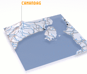 Places with similar names to Camandag, Philippines ::
// Camandag (PH)
// Camantigue (PH)
// Comandag (PH)
// Gomentoc (PH)
// Kambantug (PH)
// Kamandak (RU)
// Koumantigou (BJ)
// Kammbondogué (BF)
// Kamandougou (GN)
// Kamandougou (GN)
Disclaimer :: Information on this page comes without warranty of any kind |
||
|
Where is Camandag? Elevation and coordinates ::
Latitude (lat): 10°53'0"N Longitude (lon): 122°16'0"E
Elevation (approx.): 1064m (map arrows pan, magnifying glasses zoom) |
||
|
Visiting Camandag? Hotel/Accommodation ::
Book a hotel in Camandag Travel Guide ::
Buy a travel guide for Philippines rental cars ::
car rental offers GPS waypoint ::
download a GPX waypoint (PoI) of Camandag for your GPS receiver
|
||