|
search place name
|
||
Canlasog (Siquijor, Philippines)Canlasog is a town in the Siquijor region of Philippines. An overview map of the region around Canlasog is displayed below.
regional and 3d topo map of Canlasog, Philippines ::

Canlasog airports ::
The nearest airport is DGT - Dumaguete, located 38.2 km west of Canlasog.
Other airports nearby include NOP - Masbate Mactan Cebu Intl (124.7 km north), CGY - Ladag Cagayan De Oro (140.5 km south east), LGP - Legazpi Pagadian (156.7 km south), BCD - Bacolod (173.9 km north west), Nearby towns ::
Lotloton (1.8km east) //
Licoan (2.0km east) //
Bunga (2.2km south east) //
Basak (2.4km south west) //
Cabal-asan (2.6km south east) //
Olave (2.6km north east) //
Pari-an (2.6km north east) //
Libo (3.1km north east) //
Bogo (3.2km east) //
Balolang (3.3km north west) //
Buntod (3.3km west) //
Cang-apa (3.4km south west) //
Bino-ongan (3.7km north) //
Manan-ao (3.7km north) //
Bolot (3.7km north) //
Pisong A (4.1km south east) //
Olang (4.1km south east) //
Cantaroc B (4.1km south east) //
Cantugbas (4.1km south east) //
Logucan (4.1km south east) //
Look (4.1km south east) //
Catambu-an (4.1km north west) //
Bintangan (4.1km north west) //
Sabang (4.1km north west) //
Cabulihan (4.1km north west) //
Camugao (4.1km north east) //
Ponong (4.2km north) //
Calunasan (4.4km west) //
Maria (4.5km south east) //
[all distances 'as the bird flies' and approximate] 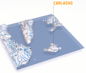 Places with similar names to Canlasog, Philippines ::
// Gönlüaçık (TR)
Disclaimer :: Information on this page comes without warranty of any kind |
||
|
Where is Canlasog? Elevation and coordinates ::
Latitude (lat): 9°14'0"N Longitude (lon): 123°38'0"E
Elevation (approx.): 321m (map arrows pan, magnifying glasses zoom) |
||
|
Visiting Canlasog? Hotel/Accommodation ::
Book a hotel in Canlasog Travel Guide ::
Buy a travel guide for Philippines rental cars ::
car rental offers GPS waypoint ::
download a GPX waypoint (PoI) of Canlasog for your GPS receiver
|
||