|
search place name
|
||
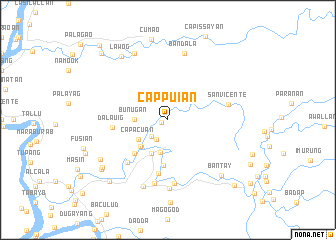
Cappuian (Cagayan, Philippines)Cappuian is a town in the Cagayan region of Philippines. An overview map of the region around Cappuian is displayed below.
regional and 3d topo map of Cappuian, Philippines ::
Cappuian airports ::
The nearest airport is BAG - Baguio, located 215.3 km south west of Cappuian.
Nearby towns ::
Carupian (0.7km west) //
Bagunut (2.5km south west) //
Ibulu (2.6km south west) //
Bunugan (3.5km west) //
Baggao (3.7km south) //
Capacuan (3.8km south west) //
Maugoguing (4.1km south west) //
Saranay (4.1km south west) //
Buenavista (4.1km south west) //
San Antonio (4.1km south west) //
Cassap (4.1km south west) //
Nueva Era (4.1km south west) //
Culling (4.1km south west) //
Nagrumboan (4.1km south west) //
Duminit (4.1km south west) //
Gagabutan (4.1km south west) //
Guyabal (4.1km south west) //
Laoageña (4.1km south west) //
Masical (4.1km south west) //
Taguing (4.2km south west) //
Canagatan (5.1km south) //
Callao (5.1km south west) //
Assasi (6.0km south) //
Dalauig (6.0km west) //
Temblique (6.4km south west) //
San Vicente (6.6km east) //
Calapian (7.1km south) //
Adaoag (7.3km south) //
Montealegre (7.6km south) //
[all distances 'as the bird flies' and approximate]  Places with similar names to Cappuian, Philippines ::
Disclaimer :: Information on this page comes without warranty of any kind |
||
|
Where is Cappuian? Elevation and coordinates ::
Latitude (lat): 17°58'0"N Longitude (lon): 121°47'0"E
Elevation (approx.): 85m (map arrows pan, magnifying glasses zoom) |
||
|
Visiting Cappuian? Hotel/Accommodation ::
Book a hotel in Cappuian Travel Guide ::
Buy a travel guide for Philippines rental cars ::
car rental offers GPS waypoint ::
download a GPX waypoint (PoI) of Cappuian for your GPS receiver
|
||