|
search place name
|
||
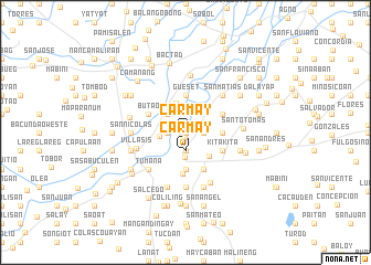
Carmay (Pangasinan, Philippines)Carmay is a town in the Pangasinan region of Philippines. An overview map of the region around Carmay is displayed below.
regional and 3d topo map of Carmay, Philippines ::
Carmay airports ::
The nearest airport is BAG - Baguio, located 50.8 km north of Carmay.
Other airports nearby include MNL - Manila Ninoy Aquino Intl (161.2 km south), Nearby towns ::
Casanicolasan (0.0km north) //
San Bartolome (0.0km north) //
Bakitbakit (0.0km north) //
Capitan Tomas (0.0km north) //
Calanutan (0.0km north) //
San Antonio (0.0km north) //
San Luis (0.0km north) //
Rizal (0.5km south) //
Caramutan (1.8km west) //
Libtong (1.8km west) //
Batikbatik (1.9km south) //
Carmay (1.9km south) //
San Nicolas (1.8km east) //
Rosales (2.5km south) //
Pias (2.6km north west) //
San Blas (2.6km west) //
Cal-litang (3.1km north) //
Balincanaway (3.3km south east) //
Samon (3.5km north east) //
Gueset (3.7km north) //
Capulaan (3.6km east) //
San Raymundo (3.6km east) //
Cabalaoangan Norte (3.7km south) //
Butao (4.0km north west) //
Timmagpao (4.0km north east) //
San Marcelino (4.0km north east) //
San Miguel (4.0km north east) //
Gallero (4.0km north east) //
Kitakita (4.0km south east) //
[all distances 'as the bird flies' and approximate]  Places with similar names to Carmay, Philippines ::
Disclaimer :: Information on this page comes without warranty of any kind |
||
|
Where is Carmay? Elevation and coordinates ::
Latitude (lat): 15°55'0"N Longitude (lon): 120°38'0"E
Elevation (approx.): 31m (map arrows pan, magnifying glasses zoom) |
||
|
Visiting Carmay? Hotel/Accommodation ::
Book a hotel in Carmay Travel Guide ::
Buy a travel guide for Philippines rental cars ::
car rental offers GPS waypoint ::
download a GPX waypoint (PoI) of Carmay for your GPS receiver
|
||