|
search place name
|
||
Catur (Ilocos Norte, Philippines)Catur is a town in the Ilocos Norte region of Philippines. An overview map of the region around Catur is displayed below.
regional and 3d topo map of Catur, Philippines ::

Catur airports ::
The nearest airport is BAG - Baguio, located 171.2 km south of Catur.
Nearby towns ::
Palisen (0.0km north) //
Ligsay (0.0km north) //
Badoc (1.5km north west) //
Morong (1.8km west) //
Paratong (1.8km west) //
Repeo (1.8km east) //
Lubigan (1.8km east) //
Lacsado (1.8km east) //
Gabut (2.6km north west) //
Tapao (2.6km south west) //
Apaya (2.6km south west) //
Parang (2.6km north east) //
Mabusag (3.2km north east) //
Apalot (3.7km north) //
Patpaten (3.5km east) //
Labut (3.7km east) //
Soucud (4.0km north west) //
Bangbanga (4.0km north west) //
Sappiguit (4.0km north west) //
Pagipit (4.0km south west) //
Napo (4.1km north east) //
Battog (4.1km south west) //
Cabaruan (4.1km south west) //
Barbar (4.0km north east) //
Parang (4.0km north east) //
Ubbog (4.1km south east) //
San Carlos (4.1km south east) //
Turod (4.0km south east) //
Pasencia (4.0km south east) //
[all distances 'as the bird flies' and approximate] 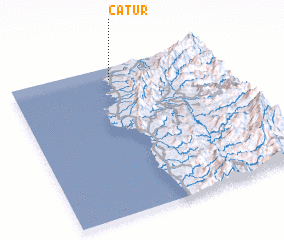 Places with similar names to Catur, Philippines ::
Disclaimer :: Information on this page comes without warranty of any kind |
||
|
Where is Catur? Elevation and coordinates ::
Latitude (lat): 17°55'0"N Longitude (lon): 120°29'0"E
Elevation (approx.): 22m (map arrows pan, magnifying glasses zoom) |
||
|
Visiting Catur? Hotel/Accommodation ::
Book a hotel in Catur Travel Guide ::
Buy a travel guide for Philippines rental cars ::
car rental offers GPS waypoint ::
download a GPX waypoint (PoI) of Catur for your GPS receiver
|
||