|
search place name
|
||
Colapnit (Camarines Sur, Philippines)Colapnit is a town in the Camarines Sur region of Philippines. An overview map of the region around Colapnit is displayed below.
regional and 3d topo map of Colapnit, Philippines ::

Nearby towns ::
Botbot (1.8km west) //
Harrison (4.0km north east) //
Del Pilar (4.0km north east) //
Danla (4.0km north east) //
Minas (4.3km south east) //
Salvacion (5.0km east) //
Pagolinan (5.2km south east) //
Canatoan (5.3km south east) //
Guijalo (5.6km east) //
San Roque (5.6km east) //
Poloan (5.8km north west) //
Lipata (5.7km east) //
Caramoan (5.8km north east) //
Bitaogan (6.2km south) //
Tabog (6.6km north east) //
Bulalacao (7.0km south west) //
Bikal (7.3km north east) //
Pagsagnahan (7.6km west) //
Antolon (7.7km north west) //
Tocangalao (7.8km south west) //
Catanagan (8.0km north west) //
Maqueda (8.1km north) //
Tabgon (8.7km north) //
Pili (8.6km south west) //
Paniman (9.4km north east) //
[all distances 'as the bird flies' and approximate] 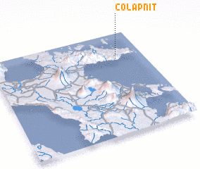 Places with similar names to Colapnit, Philippines ::
// Gull Point (US)
// Kolepant (DE)
// Klippunt (ZA)
// Cool Pond (US)
// Kelly Point (US)
// Clay Point (US)
// Kalipenta (ZM)
// Kalupenda (ZM)
// Galoi Pind (PK)
// Kālu Pind (PK)
Disclaimer :: Information on this page comes without warranty of any kind |
||
|
Where is Colapnit? Elevation and coordinates ::
Latitude (lat): 13°45'0"N Longitude (lon): 123°49'0"E
Elevation (approx.): 203m (map arrows pan, magnifying glasses zoom) |
||
|
Visiting Colapnit? Hotel/Accommodation ::
Book a hotel in Colapnit Travel Guide ::
Buy a travel guide for Philippines rental cars ::
car rental offers GPS waypoint ::
download a GPX waypoint (PoI) of Colapnit for your GPS receiver
|
||