|
search place name
|
||
Currimao (Ilocos Norte, Philippines)Currimao is a town in the Ilocos Norte region of Philippines. An overview map of the region around Currimao is displayed below.
regional and 3d topo map of Currimao, Philippines ::

Currimao airports ::
The nearest airport is BAG - Baguio, located 182.7 km south of Currimao.
Nearby towns ::
Santa Cruz (0.4km south) //
Lioes (0.4km south) //
Lang-ayang (0.9km east) //
Bimmanga (1.4km north) //
Namal-langan (1.4km north) //
Pangil (2.2km north) //
Victoria (2.7km south east) //
Torre (2.9km south east) //
Ga-ang (2.9km south east) //
Pias Norte (3.8km south east) //
Monte (3.9km east) //
Maglaoi (4.1km south) //
Maslaoi (4.1km south) //
Cubol (4.3km south east) //
Cabu-usan (4.5km south east) //
Anggapang Sur (4.5km south east) //
Panaratan (4.9km north east) //
Salindeg (5.1km north) //
Paoay (5.2km north east) //
Dalayap (5.5km south east) //
Comcomloong (5.5km south east) //
Burayoc (5.4km east) //
Callaguip (5.7km north) //
Magnuang (5.7km east) //
Darat (6.0km south) //
Takig (6.0km south) //
Ligsay (6.3km south) //
Tapao (6.3km south) //
Paratong (6.3km north east) //
[all distances 'as the bird flies' and approximate] 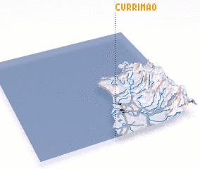 Places with similar names to Currimao, Philippines ::
Disclaimer :: Information on this page comes without warranty of any kind |
||
|
Where is Currimao? Elevation and coordinates ::
Latitude (lat): 18°1'14"N Longitude (lon): 120°28'57"E
Elevation (approx.): 19m (map arrows pan, magnifying glasses zoom) |
||
|
Visiting Currimao? Hotel/Accommodation ::
Book a hotel in Currimao Travel Guide ::
Buy a travel guide for Philippines rental cars ::
car rental offers GPS waypoint ::
download a GPX waypoint (PoI) of Currimao for your GPS receiver
|
||