|
search place name
|
||
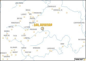
Dalapanap (Mountain, Philippines)Dalapanap is a town in the Mountain region of Philippines. An overview map of the region around Dalapanap is displayed below.
regional and 3d topo map of Dalapanap, Philippines ::
Dalapanap airports ::
The nearest airport is BAG - Baguio, located 123.6 km south west of Dalapanap.
Nearby towns ::
Masudang (1.5km south east) //
Balo (1.7km north) //
Pakawan (3.8km west) //
Mabaka (3.9km south west) //
Ganakgak (4.9km north west) //
Basao (4.9km north west) //
Palisili (4.8km north west) //
Kalao (4.8km north west) //
Pagga (6.0km north west) //
Lutang (6.4km west) //
Pasaking (6.9km north) //
Lettung (7.4km north west) //
Bonaffa (7.3km west) //
Obfal (7.6km south west) //
Bai (8.0km north west) //
Bongabo (7.9km west) //
Babba (7.9km west) //
Licoy (8.4km south west) //
Bacari (8.9km north west) //
Ambogao (9.1km south) //
Butigui (9.3km south) //
Bogui (9.9km north west) //
Limpat (9.8km north west) //
Paracelis (10.1km north east) //
Oobi (10.7km south east) //
Tappo (11.8km south west) //
[all distances 'as the bird flies' and approximate] 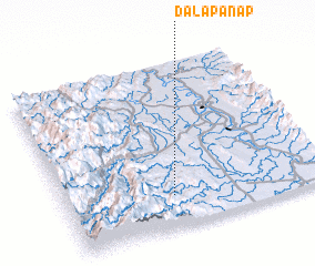 Places with similar names to Dalapanap, Philippines :: Disclaimer :: Information on this page comes without warranty of any kind |
||
|
Where is Dalapanap? Elevation and coordinates ::
Latitude (lat): 17°11'45"N Longitude (lon): 121°24'24"E
Elevation (approx.): 184m (map arrows pan, magnifying glasses zoom) |
||
|
Visiting Dalapanap? Hotel/Accommodation ::
Book a hotel in Dalapanap Travel Guide ::
Buy a travel guide for Philippines rental cars ::
car rental offers GPS waypoint ::
download a GPX waypoint (PoI) of Dalapanap for your GPS receiver
|
||