|
search place name
|
||
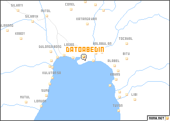
Dato Abedin (General Santos, Philippines)Dato Abedin is a town in the General Santos region of Philippines. An overview map of the region around Dato Abedin is displayed below.
regional and 3d topo map of Dato Abedin, Philippines ::
Dato Abedin airports ::
The nearest airport is CEB - Cebu Cotabato, located 162.1 km north west of Dato Abedin.
Other airports nearby include LGP - Legazpi Pagadian (272.5 km north west), Nearby towns ::
Baluan (0.4km north) //
Buanan (1.8km east) //
Bula (2.7km west) //
Buayan (2.9km north east) //
Lagao (4.0km north west) //
Labañgal (4.1km north east) //
Bianan (4.1km north east) //
Lot (4.1km north east) //
Malabulan (4.7km north east) //
General Santos (4.8km west) //
Labangal (6.1km west) //
Alabel (6.6km east) //
Calumpang (7.3km west) //
Togakulasa (7.4km west) //
Ladol (7.6km east) //
Dulongabong (7.8km west) //
Lun-Grande (7.8km south east) //
Makar (7.8km west) //
Katangawan (8.1km north) //
Kawas (8.1km south east) //
Kulutansa (8.1km south west) //
Tambler (9.3km south west) //
Lun-Pequeño (10.3km south east) //
Bila (11.1km south east) //
Supu (11.5km south west) //
[all distances 'as the bird flies' and approximate] 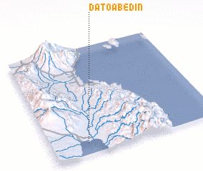 Places with similar names to Dato Abedin, Philippines :: Disclaimer :: Information on this page comes without warranty of any kind |
||
|
Where is Dato Abedin? Elevation and coordinates ::
Latitude (lat): 6°6'0"N Longitude (lon): 125°13'0"E
(map arrows pan, magnifying glasses zoom) |
||
|
Visiting Dato Abedin? Hotel/Accommodation ::
Book a hotel in Dato Abedin Travel Guide ::
Buy a travel guide for Philippines rental cars ::
car rental offers GPS waypoint ::
download a GPX waypoint (PoI) of Dato Abedin for your GPS receiver
|
||