|
search place name
|
||
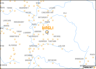
Dingli (Abra, Philippines)Dingli is a town in the Abra region of Philippines. An overview map of the region around Dingli is displayed below.
regional and 3d topo map of Dingli, Philippines ::
Dingli airports ::
The nearest airport is BAG - Baguio, located 93.9 km south of Dingli.
Nearby towns ::
Musing (1.8km west) //
Balakinunu (1.8km east) //
Danao (1.9km south) //
Bebiac (2.6km north west) //
Tiking (2.6km south west) //
Banaue (2.6km south east) //
Dadatagan (2.6km south east) //
Anap (2.6km south east) //
Abbey (2.6km south east) //
Cauayan (2.6km south east) //
Dilong (2.6km south east) //
Ubanan (3.5km west) //
Pakia (3.7km north) //
Mapga (3.7km south) //
Biweng (4.1km north west) //
Lauc (4.1km north west) //
Ngina (4.1km north west) //
Balacnono (4.1km north west) //
Kumanga (4.1km south west) //
Tubtuba (4.1km south east) //
Macapay (4.1km south east) //
Mayang (4.0km south east) //
Tabatab (4.9km south west) //
Timuken (5.1km north west) //
Laglogan (5.1km north west) //
Canteng (5.1km south west) //
Oayangan (5.5km north west) //
Bermarekbec (5.3km west) //
Quilaman (5.3km west) //
[all distances 'as the bird flies' and approximate] 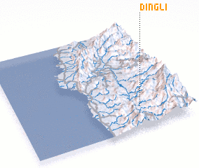 Places with similar names to Dingli, Philippines ::
Disclaimer :: Information on this page comes without warranty of any kind |
||
|
Where is Dingli? Elevation and coordinates ::
Latitude (lat): 17°13'0"N Longitude (lon): 120°44'0"E
Elevation (approx.): 851m (map arrows pan, magnifying glasses zoom) |
||
|
Visiting Dingli? Hotel/Accommodation ::
Book a hotel in Dingli Travel Guide ::
Buy a travel guide for Philippines rental cars ::
car rental offers GPS waypoint ::
download a GPX waypoint (PoI) of Dingli for your GPS receiver
|
||