|
search place name
|
||
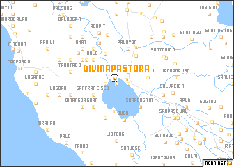
Divina Pastora (Camarines Sur, Philippines)Divina Pastora is a town in the Camarines Sur region of Philippines. An overview map of the region around Divina Pastora is displayed below.
regional and 3d topo map of Divina Pastora, Philippines ::
Divina Pastora airports ::
The nearest airport is KLO - Kalibo, located 213.0 km south west of Divina Pastora.
Nearby towns ::
Lobigan (0.0km north) //
San Roque (0.0km north) //
Santa Cruz (0.0km north) //
Salvacion (0.0km north) //
Santo Niño (0.0km north) //
Bato (1.6km north east) //
Patag (1.8km west) //
San Juan (1.8km west) //
Cristo Rey (1.8km east) //
Pagatpatan (1.8km east) //
San Vicente (2.5km north east) //
Agos (2.6km north east) //
San Ramon (3.7km north east) //
San Francisco (4.1km south west) //
Buluang (4.5km south) //
Masuli (4.9km east) //
Dolorosa (5.0km north) //
Bacolod (5.2km south west) //
Bolo (5.2km north west) //
Katubtagan (5.2km north west) //
San Agustin (5.2km south east) //
Santiago (5.3km north east) //
Nasignit (5.8km south) //
Baras (5.8km north) //
Matagbac (5.8km north) //
Naipitan (5.8km north) //
Ogbon (5.8km north) //
Pacifico (5.8km north) //
Paloyon (5.8km north) //
[all distances 'as the bird flies' and approximate]  Places with similar names to Divina Pastora, Philippines ::
// Divina Pastora (VE)
// Divina Pastôra (BR)
Disclaimer :: Information on this page comes without warranty of any kind |
||
|
Where is Divina Pastora? Elevation and coordinates ::
Latitude (lat): 13°21'0"N Longitude (lon): 123°21'0"E
Elevation (approx.): 4m (map arrows pan, magnifying glasses zoom) |
||
|
Visiting Divina Pastora? Hotel/Accommodation ::
Book a hotel in Divina Pastora Travel Guide ::
Buy a travel guide for Philippines rental cars ::
car rental offers GPS waypoint ::
download a GPX waypoint (PoI) of Divina Pastora for your GPS receiver
|
||