|
search place name
|
||
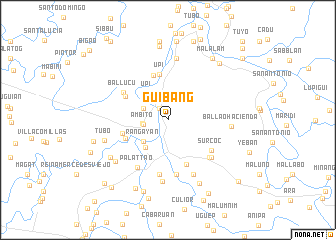
Guibang (Isabela, Philippines)Guibang is a town in the Isabela region of Philippines. An overview map of the region around Guibang is displayed below.
regional and 3d topo map of Guibang, Philippines ::
Guibang airports ::
The nearest airport is BAG - Baguio, located 152.0 km south west of Guibang.
Nearby towns ::
Anipa (1.6km north west) //
Lanteng (2.7km west) //
Masigun (2.7km west) //
Baramban (2.7km west) //
Holy Friday (2.7km west) //
Pisang (2.7km west) //
Pintor (2.7km west) //
Basilio (2.7km west) //
Taroc (2.7km west) //
Lucban (2.7km west) //
Ambito (2.7km west) //
Pata (2.7km west) //
Gamu (2.7km west) //
Upi (2.9km north west) //
Biculod (2.9km north west) //
Placar (3.5km south west) //
Flores (3.5km south west) //
Luna (3.5km south west) //
Rañgayan (3.5km south west) //
Cabaruan (3.5km south west) //
Upi (3.7km north west) //
Naguilian (4.0km south west) //
Upi (5.1km north) //
Alibagu (5.1km north) //
Lenon (4.9km south west) //
Pilar (5.2km north) //
Furao (5.1km west) //
Catungauan (5.3km south) //
Damao (5.2km north west) //
[all distances 'as the bird flies' and approximate] 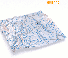 Places with similar names to Guibang, Philippines ::
Disclaimer :: Information on this page comes without warranty of any kind |
||
|
Where is Guibang? Elevation and coordinates ::
Latitude (lat): 17°3'17"N Longitude (lon): 121°51'29"E
Elevation (approx.): 52m (map arrows pan, magnifying glasses zoom) |
||
|
Visiting Guibang? Hotel/Accommodation ::
Book a hotel in Guibang Travel Guide ::
Buy a travel guide for Philippines rental cars ::
car rental offers GPS waypoint ::
download a GPX waypoint (PoI) of Guibang for your GPS receiver
|
||