|
search place name
|
||
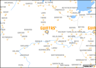
Guintas (Capiz, Philippines)Guintas is a town in the Capiz region of Philippines. An overview map of the region around Guintas is displayed below.
regional and 3d topo map of Guintas, Philippines ::
Guintas airports ::
The nearest airport is KLO - Kalibo, located 29.6 km north west of Guintas.
Other airports nearby include ILO - Iloilo (80.0 km south), SJI - San Jose Antique (95.2 km south west), BCD - Bacolod (100.2 km south east), NOP - Masbate Mactan Cebu Intl (205.6 km south east), Nearby towns ::
Milan (1.6km north west) //
Aglicabao (1.8km west) //
Ma-antol (2.6km north east) //
Lucero (3.5km north west) //
Bula (3.6km east) //
Molit (3.7km south) //
Jamindan (4.1km south east) //
Igang (4.1km north west) //
Linambasan (4.1km south east) //
Bayebaye (4.1km south east) //
Agloloway (4.1km south east) //
Caridad (4.1km south east) //
Aglibacao (4.1km south east) //
San Vicente (4.1km south east) //
Esperanza (4.1km south east) //
Fé (4.1km south east) //
San Jose (4.1km south east) //
Caidquid (4.2km south east) //
Masgrau (4.4km south) //
Pasol-o (5.2km south west) //
Agcagay (5.4km east) //
Pañgabat (5.6km south) //
Garcia (5.6km south) //
Tibiao (5.8km north) //
Pañgabuan (5.9km east) //
Jagnaya (6.6km south east) //
Catmon (6.6km north east) //
Jaena Norte (6.7km south west) //
La Paz (6.9km south) //
[all distances 'as the bird flies' and approximate] 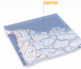 Places with similar names to Guintas, Philippines ::
Disclaimer :: Information on this page comes without warranty of any kind |
||
|
Where is Guintas? Elevation and coordinates ::
Latitude (lat): 11°26'0"N Longitude (lon): 122°29'0"E
Elevation (approx.): 50m (map arrows pan, magnifying glasses zoom) |
||
|
Visiting Guintas? Hotel/Accommodation ::
Book a hotel in Guintas Travel Guide ::
Buy a travel guide for Philippines rental cars ::
car rental offers GPS waypoint ::
download a GPX waypoint (PoI) of Guintas for your GPS receiver
|
||