|
search place name
|
||
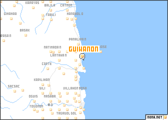
Guiwanon (Cebu, Philippines)Guiwanon is a town in the Cebu region of Philippines. An overview map of the region around Guiwanon is displayed below.
regional and 3d topo map of Guiwanon, Philippines ::
Guiwanon airports ::
The nearest airport is NOP - Masbate Mactan Cebu Intl, located 34.7 km south of Guiwanon.
Other airports nearby include BCD - Bacolod (120.8 km west), TAC - Tacloban Daniel Z Romualdez (128.0 km north east), DGT - Dumaguete (163.1 km south west), ILO - Iloilo (163.2 km west), Nearby towns ::
Luyang (1.3km south west) //
Fuente (1.8km west) //
Malbago (1.9km south) //
Binongkalan (2.2km north west) //
Sagpon (2.6km north west) //
Kantokong (2.6km north west) //
Baring (2.6km south west) //
Cogon (2.6km south west) //
Boyo (2.9km north) //
Carmen (3.1km south west) //
Panalipan (3.7km north) //
Aron (4.1km north west) //
Cantucong (4.1km south west) //
San Jose (4.1km north east) //
Dawis Norte (4.8km south) //
Ipil (5.4km south west) //
Lantawan (5.5km west) //
Mago (5.8km west) //
Cantumog (5.8km west) //
Natimaoan (7.0km west) //
Basac (7.5km west) //
Villa Hermosa (7.6km south) //
But (7.6km south) //
Pangdan (7.6km south) //
Guinsay (7.9km south) //
Catmondaan (8.0km north) //
Binalio (8.3km south west) //
Hagnaya (8.3km south west) //
Cagat (8.3km south west) //
[all distances 'as the bird flies' and approximate] 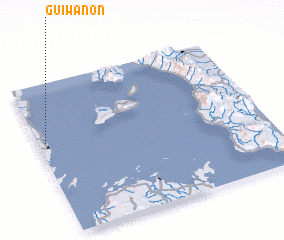 Places with similar names to Guiwanon, Philippines ::
Disclaimer :: Information on this page comes without warranty of any kind |
||
|
Where is Guiwanon? Elevation and coordinates ::
Latitude (lat): 10°37'0"N Longitude (lon): 124°2'0"E
Elevation (approx.): -32768m (map arrows pan, magnifying glasses zoom) |
||
|
Visiting Guiwanon? Hotel/Accommodation ::
Book a hotel in Guiwanon Travel Guide ::
Buy a travel guide for Philippines rental cars ::
car rental offers GPS waypoint ::
download a GPX waypoint (PoI) of Guiwanon for your GPS receiver
|
||