|
search place name
|
||
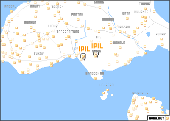
Ipil (Sulu, Philippines)Ipil is a town in the Sulu region of Philippines. An overview map of the region around Ipil is displayed below.
regional and 3d topo map of Ipil, Philippines ::
Ipil airports ::
The nearest airport is ZAM - Zamboanga Intl, located 157.8 km north east of Ipil.
Nearby towns ::
Patao (0.8km west) //
Dandulit (2.2km north west) //
Li”dung (2.2km north west) //
Maimbung (2.2km north west) //
Lumapid (2.5km north east) //
Ipil (2.8km east) //
Lapa (3.5km west) //
Binuang (4.5km north) //
Bangcowan (4.5km south east) //
Gulangan (4.7km north west) //
Bualo Lahi (4.7km west) //
Bualo Lipid (4.8km west) //
Tiis (5.1km north east) //
Talipaw (5.4km east) //
Kulasi (6.1km west) //
Kunalum (6.2km north west) //
Tando Patung (6.4km north west) //
Matatal (6.5km north west) //
Tubig Samin (6.7km north west) //
Marsada (6.8km east) //
Niug Sangahan (7.0km north east) //
Bandang (7.0km north) //
Bangon Banga (7.0km east) //
Samak (7.1km north east) //
Lagtoh (7.1km north) //
Bual Nangka (7.1km east) //
Lagasan Asibi (7.4km west) //
Lerong (7.5km west) //
Pantao (7.6km north) //
[all distances 'as the bird flies' and approximate]  Places with similar names to Ipil, Philippines ::
Disclaimer :: Information on this page comes without warranty of any kind |
||
|
Where is Ipil? Elevation and coordinates ::
Latitude (lat): 5°55'7"N Longitude (lon): 121°2'47"E
Elevation (approx.): 16m (map arrows pan, magnifying glasses zoom) |
||
|
Visiting Ipil? Hotel/Accommodation ::
Book a hotel in Ipil Travel Guide ::
Buy a travel guide for Philippines rental cars ::
car rental offers GPS waypoint ::
download a GPX waypoint (PoI) of Ipil for your GPS receiver
|
||