|
search place name
|
||
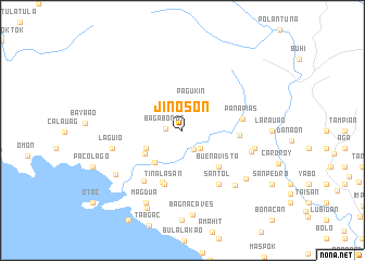
Jinoson (Camarines Sur, Philippines)Jinoson is a town in the Camarines Sur region of Philippines. An overview map of the region around Jinoson is displayed below.
regional and 3d topo map of Jinoson, Philippines ::
Jinoson airports ::
The nearest airport is MNL - Manila Ninoy Aquino Intl, located 207.2 km west of Jinoson.
Nearby towns ::
Bagabonot (1.7km west) //
Mancanda (2.2km south east) //
Abuyog (2.6km south east) //
Pagukin (3.1km north) //
Cabagnajan (4.0km south west) //
Ragay (4.3km south west) //
Panaytayan (4.4km south west) //
Buenavista (5.2km south east) //
Cale (5.7km south) //
Tinalasan (5.8km south) //
Naghoom (5.8km south) //
Mambog (5.7km east) //
Panapias (6.2km east) //
Apali (6.4km south west) //
Santol (6.6km south east) //
Laguio (7.2km west) //
Casay (7.3km east) //
Calamitas (7.4km east) //
San Rafael (7.7km south east) //
Hindug (8.0km south west) //
Salvacion (8.1km south east) //
Magdua (8.2km south west) //
Bagña Caves (8.7km south) //
Badi (8.7km south west) //
[all distances 'as the bird flies' and approximate] 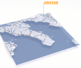 Places with similar names to Jinoson, Philippines ::
Disclaimer :: Information on this page comes without warranty of any kind |
||
|
Where is Jinoson? Elevation and coordinates ::
Latitude (lat): 13°51'0"N Longitude (lon): 122°49'0"E
Elevation (approx.): 89m (map arrows pan, magnifying glasses zoom) |
||
|
Visiting Jinoson? Hotel/Accommodation ::
Book a hotel in Jinoson Travel Guide ::
Buy a travel guide for Philippines rental cars ::
car rental offers GPS waypoint ::
download a GPX waypoint (PoI) of Jinoson for your GPS receiver
|
||