|
search place name
|
||
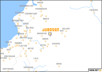
Jubasan (Samar, Philippines)Jubasan is a town in the Samar region of Philippines. An overview map of the region around Jubasan is displayed below.
regional and 3d topo map of Jubasan, Philippines ::
Jubasan airports ::
The nearest airport is TAC - Tacloban Daniel Z Romualdez, located 43.8 km south of Jubasan.
Other airports nearby include NOP - Masbate Mactan Cebu Intl (189.7 km south west), Nearby towns ::
Mayuan (2.6km north east) //
Tuguib (2.6km north east) //
Abane (2.8km south west) //
Cangalong (3.2km south) //
Mahancao (3.4km west) //
Litiron (4.0km south) //
Biri (4.0km east) //
Hindang (4.1km south east) //
Gadgaran (4.9km east) //
Antol (5.1km south west) //
Buluan (5.8km east) //
Abaca (5.8km north) //
San Mauricio (6.0km south west) //
Canluagon (6.4km south west) //
Nonoc (6.6km south west) //
Camambanan (7.6km north) //
Otoc (7.7km west) //
Panayoran (7.7km west) //
Polañgi (7.9km west) //
Bucalan (8.3km north west) //
Canano (8.5km north) //
Bulao (8.6km west) //
Benobucalan (9.2km north west) //
Botoc (9.1km south west) //
Carabatuan (10.4km north west) //
[all distances 'as the bird flies' and approximate]  Places with similar names to Jubasan, Philippines ::
Disclaimer :: Information on this page comes without warranty of any kind |
||
|
Where is Jubasan? Elevation and coordinates ::
Latitude (lat): 11°37'0"N Longitude (lon): 125°6'0"E
Elevation (approx.): 215m (map arrows pan, magnifying glasses zoom) |
||
|
Visiting Jubasan? Hotel/Accommodation ::
Book a hotel in Jubasan Travel Guide ::
Buy a travel guide for Philippines rental cars ::
car rental offers GPS waypoint ::
download a GPX waypoint (PoI) of Jubasan for your GPS receiver
|
||