|
search place name
|
||
Kabayan (Benguet, Philippines)Kabayan is a town in the Benguet region of Philippines. An overview map of the region around Kabayan is displayed below.
regional and 3d topo map of Kabayan, Philippines ::

Kabayan airports ::
The nearest airport is BAG - Baguio, located 36.2 km south west of Kabayan.
Nearby towns ::
Kabayan (2.2km north west) //
Gusaran (2.6km north west) //
Adud (2.9km south) //
Kagosit (3.6km south) //
Coplow (4.6km south) //
Adaoay (4.6km south) //
Batan (5.0km west) //
Pacso (5.4km north west) //
Bila (6.4km south) //
Apunan (6.4km south) //
Ellet (7.6km south west) //
Socong (7.7km south west) //
Buncalo (8.0km west) //
Amlimay (8.5km north) //
Apunan (8.4km west) //
Ganaba (9.0km south east) //
Naoal (10.1km south west) //
Cabayo (10.4km south east) //
Balete (10.3km south east) //
Pilig (10.3km south east) //
Tinoc (10.6km north east) //
Tamangan (11.6km south east) //
[all distances 'as the bird flies' and approximate] 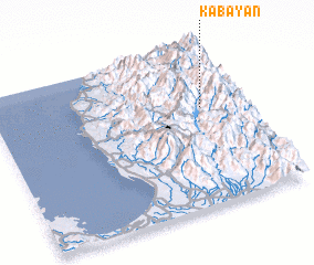 Places with similar names to Kabayan, Philippines ::
Disclaimer :: Information on this page comes without warranty of any kind |
||
|
Where is Kabayan? Elevation and coordinates ::
Latitude (lat): 16°37'26"N Longitude (lon): 120°50'25"E
Elevation (approx.): 1233m (map arrows pan, magnifying glasses zoom) |
||
|
Visiting Kabayan? Hotel/Accommodation ::
Book a hotel in Kabayan Travel Guide ::
Buy a travel guide for Philippines rental cars ::
car rental offers GPS waypoint ::
download a GPX waypoint (PoI) of Kabayan for your GPS receiver
|
||